You are here: Home > Network List > UW - Pacific Northwest Regional Seismic Network Stations List
> Station UMAT Pilot Rock, OR, USA > Earthquake Result Viewer
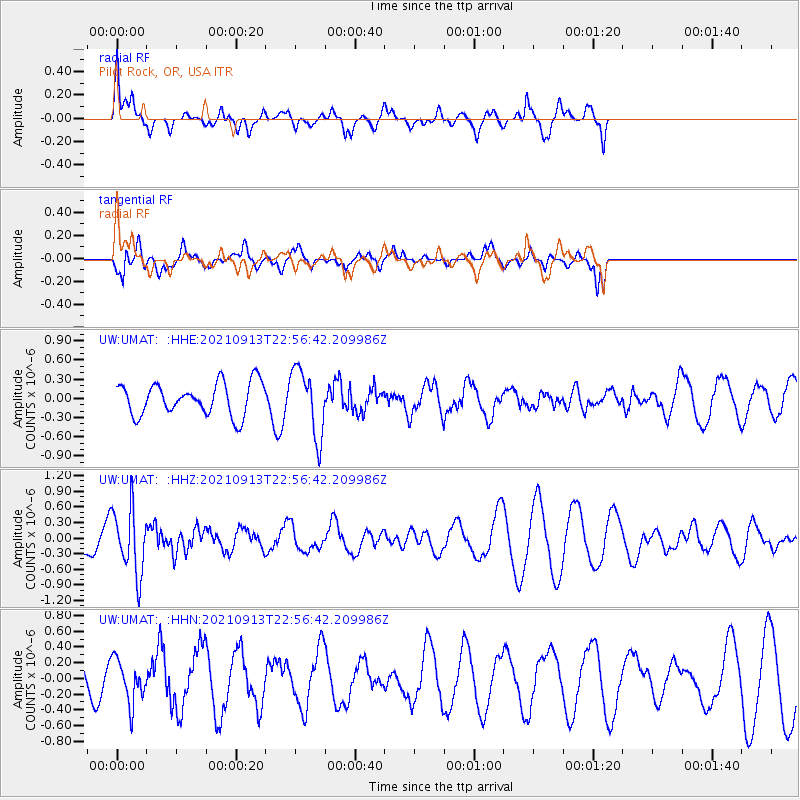
UMAT Pilot Rock, OR, USA - Earthquake Result Viewer
*The percent match for this event was below the threshold and hence no stack was calculated.
| Earthquake location: |
Southeast Of Honshu, Japan |
| Earthquake latitude/longitude: |
32.4/137.9 |
| Earthquake time(UTC): |
2021/09/13 (256) 22:46:06 GMT |
| Earthquake Depth: |
376 km |
| Earthquake Magnitude: |
5.9 Mww |
| Earthquake Catalog/Contributor: |
NEIC PDE/us |
|
| Network: |
UW Pacific Northwest Regional Seismic Network |
| Station: |
UMAT Pilot Rock, OR, USA |
| Lat/Lon: |
45.29 N/118.96 W |
| Elevation: |
1318 m |
|
| Distance: |
76.0 deg |
| Az: |
45.116 deg |
| Baz: |
301.911 deg |
| Ray Param: |
$rayparam |
*The percent match for this event was below the threshold and hence was not used in the summary stack. |
|
| Radial Match: |
57.229702 % |
| Radial Bump: |
400 |
| Transverse Match: |
55.557774 % |
| Transverse Bump: |
275 |
| SOD ConfigId: |
25131211 |
| Insert Time: |
2021-09-27 23:13:23.617 +0000 |
| GWidth: |
2.5 |
| Max Bumps: |
400 |
| Tol: |
0.001 |
|
Signal To Noise
| Channel | StoN | STA | LTA |
| UW:UMAT: :HHZ:20210913T22:56:42.209986Z | 2.6285377 | 6.245641E-7 | 2.3760897E-7 |
| UW:UMAT: :HHN:20210913T22:56:42.209986Z | 1.1558841 | 2.7116369E-7 | 2.3459417E-7 |
| UW:UMAT: :HHE:20210913T22:56:42.209986Z | 2.1004438 | 5.261684E-7 | 2.505034E-7 |
| Arrivals |
| Ps | |
| PpPs | |
| PsPs/PpSs | |


