You are here: Home > Network List > UW - Pacific Northwest Regional Seismic Network Stations List
> Station MULN Lyman, WA, USA > Earthquake Result Viewer
MULN Lyman, WA, USA - Earthquake Result Viewer
| Earthquake location: |
Southeast Of Honshu, Japan |
| Earthquake latitude/longitude: |
32.4/137.9 |
| Earthquake time(UTC): |
2021/09/13 (256) 22:46:06 GMT |
| Earthquake Depth: |
376 km |
| Earthquake Magnitude: |
5.9 Mww |
| Earthquake Catalog/Contributor: |
NEIC PDE/us |
|
| Network: |
UW Pacific Northwest Regional Seismic Network |
| Station: |
MULN Lyman, WA, USA |
| Lat/Lon: |
48.54 N/122.06 W |
| Elevation: |
102 m |
|
| Distance: |
72.5 deg |
| Az: |
43.336 deg |
| Baz: |
299.165 deg |
| Ray Param: |
0.052513536 |
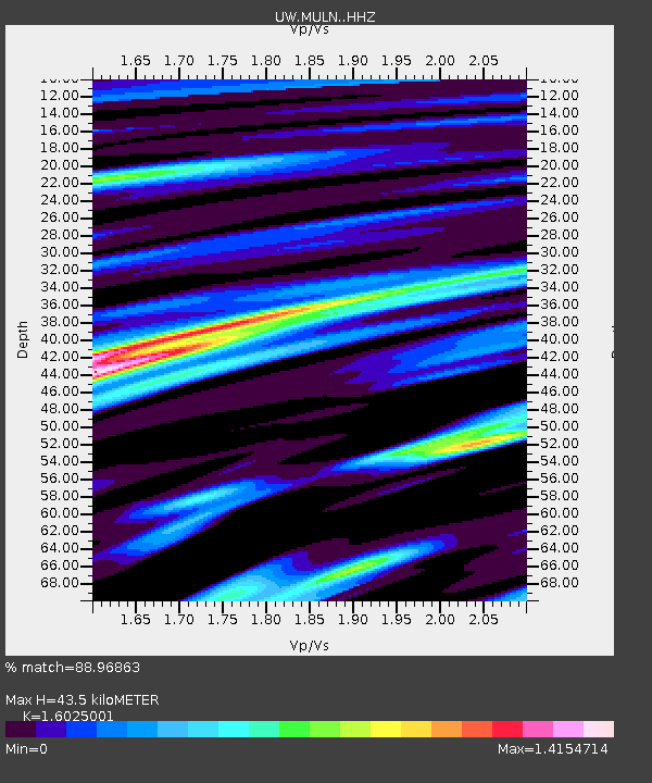
| Estimated Moho Depth: |
43.5 km |
| Estimated Crust Vp/Vs: |
1.60 |
| Assumed Crust Vp: |
6.566 km/s |
| Estimated Crust Vs: |
4.097 km/s |
| Estimated Crust Poisson's Ratio: |
0.18 |
|
| Radial Match: |
88.96863 % |
| Radial Bump: |
400 |
| Transverse Match: |
84.40093 % |
| Transverse Bump: |
384 |
| SOD ConfigId: |
25131211 |
| Insert Time: |
2021-09-27 23:13:49.403 +0000 |
| GWidth: |
2.5 |
| Max Bumps: |
400 |
| Tol: |
0.001 |
|

Signal To Noise
| Channel | StoN | STA | LTA |
| UW:MULN: :HHZ:20210913T22:56:22.38003Z | 4.4175534 | 9.937631E-7 | 2.2495782E-7 |
| UW:MULN: :HHN:20210913T22:56:22.38003Z | 1.6907746 | 4.694982E-7 | 2.7768232E-7 |
| UW:MULN: :HHE:20210913T22:56:22.38003Z | 1.6227039 | 5.272468E-7 | 3.2491866E-7 |
| Arrivals |
| Ps | 4.1 SECOND |
| PpPs | 17 SECOND |
| PsPs/PpSs | 21 SECOND |


