You are here: Home > Network List > NR - NARS Array Stations List
> Station NE76 Mulege, Mexico > Earthquake Result Viewer
NE76 Mulege, Mexico - Earthquake Result Viewer
| Earthquake location: |
Kamchatka Peninsula, Russia |
| Earthquake latitude/longitude: |
55.7/160.0 |
| Earthquake time(UTC): |
2004/06/10 (162) 15:19:57 GMT |
| Earthquake Depth: |
189 km |
| Earthquake Magnitude: |
6.1 MB, 6.9 MW, 6.9 MW |
| Earthquake Catalog/Contributor: |
WHDF/NEIC |
|
| Network: |
NR NARS Array |
| Station: |
NE76 Mulege, Mexico |
| Lat/Lon: |
26.89 N/112.00 W |
| Elevation: |
35 m |
|
| Distance: |
67.1 deg |
| Az: |
75.606 deg |
| Baz: |
322.102 deg |
| Ray Param: |
0.056609333 |
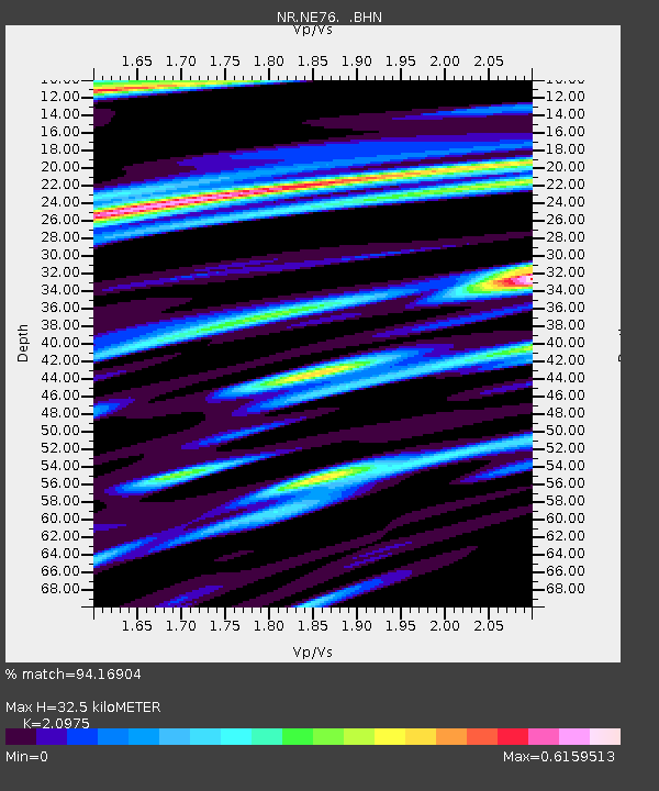
| Estimated Moho Depth: |
32.5 km |
| Estimated Crust Vp/Vs: |
2.10 |
| Assumed Crust Vp: |
6.183 km/s |
| Estimated Crust Vs: |
2.948 km/s |
| Estimated Crust Poisson's Ratio: |
0.35 |
|
| Radial Match: |
94.16904 % |
| Radial Bump: |
400 |
| Transverse Match: |
79.56441 % |
| Transverse Bump: |
400 |
| SOD ConfigId: |
2459 |
| Insert Time: |
2010-03-09 12:45:00.219 +0000 |
| GWidth: |
2.5 |
| Max Bumps: |
400 |
| Tol: |
0.001 |
|

Signal To Noise
| Channel | StoN | STA | LTA |
| NR:NE76: :BHN:20040610T15:30:00.296021Z | 4.5659637 | 1.0716603E-6 | 2.3470626E-7 |
| NR:NE76: :BHE:20040610T15:30:00.296021Z | 2.0456119 | 1.0096148E-6 | 4.935515E-7 |
| NR:NE76: :BHZ:20040610T15:30:00.296021Z | 10.676431 | 3.2090336E-6 | 3.0057174E-7 |
| Arrivals |
| Ps | 5.9 SECOND |
| PpPs | 16 SECOND |
| PsPs/PpSs | 22 SECOND |


