You are here: Home > Network List > NR - NARS Array Stations List
> Station NE76 Mulege, Mexico > Earthquake Result Viewer
NE76 Mulege, Mexico - Earthquake Result Viewer
| Earthquake location: |
Northern Peru |
| Earthquake latitude/longitude: |
-5.7/-76.4 |
| Earthquake time(UTC): |
2005/09/26 (269) 01:55:37 GMT |
| Earthquake Depth: |
115 km |
| Earthquake Magnitude: |
6.7 MB, 7.5 MW, 7.5 MW |
| Earthquake Catalog/Contributor: |
WHDF/NEIC |
|
| Network: |
NR NARS Array |
| Station: |
NE76 Mulege, Mexico |
| Lat/Lon: |
26.89 N/112.00 W |
| Elevation: |
35 m |
|
| Distance: |
47.3 deg |
| Az: |
314.952 deg |
| Baz: |
127.948 deg |
| Ray Param: |
0.06970545 |
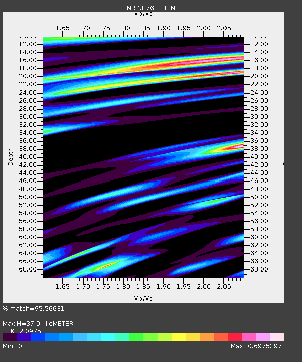
| Estimated Moho Depth: |
37.0 km |
| Estimated Crust Vp/Vs: |
2.10 |
| Assumed Crust Vp: |
6.183 km/s |
| Estimated Crust Vs: |
2.948 km/s |
| Estimated Crust Poisson's Ratio: |
0.35 |
|
| Radial Match: |
95.56631 % |
| Radial Bump: |
400 |
| Transverse Match: |
86.33554 % |
| Transverse Bump: |
400 |
| SOD ConfigId: |
2564 |
| Insert Time: |
2010-03-09 12:45:05.200 +0000 |
| GWidth: |
2.5 |
| Max Bumps: |
400 |
| Tol: |
0.001 |
|

Signal To Noise
| Channel | StoN | STA | LTA |
| NR:NE76: :BHN:20050926T02:03:28.922014Z | 13.1518545 | 4.882249E-6 | 3.7122135E-7 |
| NR:NE76: :BHE:20050926T02:03:28.922014Z | 11.379838 | 5.41112E-6 | 4.7550066E-7 |
| NR:NE76: :BHZ:20050926T02:03:28.922014Z | 41.384136 | 1.3709887E-5 | 3.3128362E-7 |
| Arrivals |
| Ps | 6.9 SECOND |
| PpPs | 18 SECOND |
| PsPs/PpSs | 25 SECOND |


