You are here: Home > Network List > NR - NARS Array Stations List
> Station NE76 Mulege, Mexico > Earthquake Result Viewer
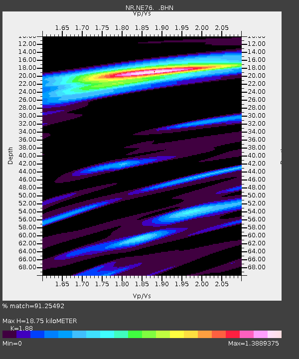
NE76 Mulege, Mexico - Earthquake Result Viewer
| Earthquake location: |
New Ireland Region, P.N.G. |
| Earthquake latitude/longitude: |
-4.5/153.5 |
| Earthquake time(UTC): |
2005/09/09 (252) 07:26:43 GMT |
| Earthquake Depth: |
90 km |
| Earthquake Magnitude: |
6.3 MB, 7.7 MW, 7.5 MW |
| Earthquake Catalog/Contributor: |
WHDF/NEIC |
|
| Network: |
NR NARS Array |
| Station: |
NE76 Mulege, Mexico |
| Lat/Lon: |
26.89 N/112.00 W |
| Elevation: |
35 m |
|
| Distance: |
96.1 deg |
| Az: |
63.551 deg |
| Baz: |
267.994 deg |
| Ray Param: |
0.040554173 |
| Estimated Moho Depth: |
18.75 km |
| Estimated Crust Vp/Vs: |
1.88 |
| Assumed Crust Vp: |
6.183 km/s |
| Estimated Crust Vs: |
3.289 km/s |
| Estimated Crust Poisson's Ratio: |
0.30 |
|
| Radial Match: |
91.25492 % |
| Radial Bump: |
400 |
| Transverse Match: |
77.28286 % |
| Transverse Bump: |
400 |
| SOD ConfigId: |
2564 |
| Insert Time: |
2010-03-09 12:45:06.049 +0000 |
| GWidth: |
2.5 |
| Max Bumps: |
400 |
| Tol: |
0.001 |
|

Signal To Noise
| Channel | StoN | STA | LTA |
| NR:NE76: :BHN:20050909T07:39:29.75002Z | 0.4307856 | 7.6393576E-8 | 1.773355E-7 |
| NR:NE76: :BHE:20050909T07:39:29.75002Z | 1.1357625 | 2.5070474E-7 | 2.2073696E-7 |
| NR:NE76: :BHZ:20050909T07:39:29.75002Z | 8.148422 | 7.765543E-7 | 9.530119E-8 |
| Arrivals |
| Ps | 2.7 SECOND |
| PpPs | 8.6 SECOND |
| PsPs/PpSs | 11 SECOND |


