You are here: Home > Network List > NR - NARS Array Stations List
> Station NE76 Mulege, Mexico > Earthquake Result Viewer
NE76 Mulege, Mexico - Earthquake Result Viewer
| Earthquake location: |
Tonga Islands |
| Earthquake latitude/longitude: |
-20.6/-173.9 |
| Earthquake time(UTC): |
2006/05/17 (137) 03:06:16 GMT |
| Earthquake Depth: |
10 km |
| Earthquake Magnitude: |
5.8 MB, 5.8 MS, 6.0 MW, 5.8 MW |
| Earthquake Catalog/Contributor: |
WHDF/NEIC |
|
| Network: |
NR NARS Array |
| Station: |
NE76 Mulege, Mexico |
| Lat/Lon: |
26.89 N/112.00 W |
| Elevation: |
35 m |
|
| Distance: |
76.4 deg |
| Az: |
54.2 deg |
| Baz: |
238.274 deg |
| Ray Param: |
0.051043183 |
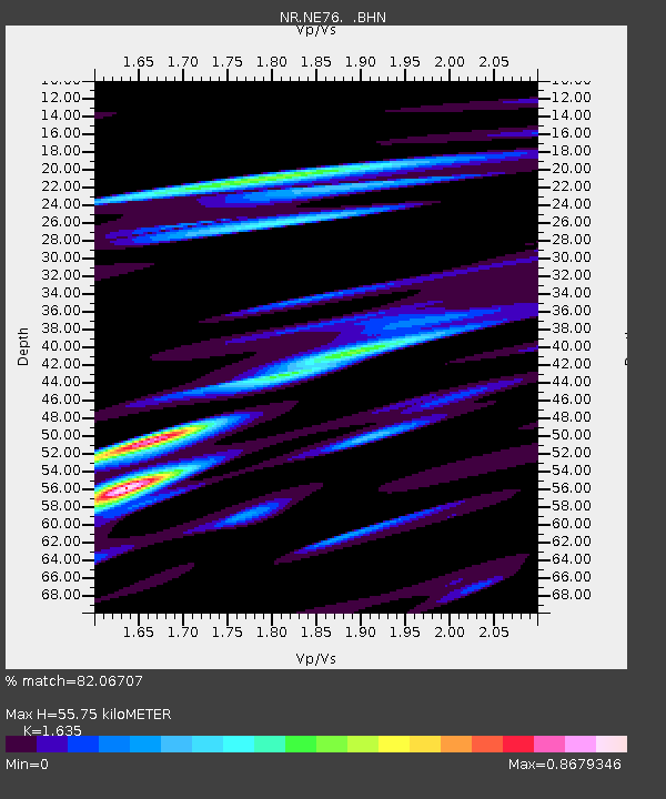
| Estimated Moho Depth: |
55.75 km |
| Estimated Crust Vp/Vs: |
1.63 |
| Assumed Crust Vp: |
6.183 km/s |
| Estimated Crust Vs: |
3.781 km/s |
| Estimated Crust Poisson's Ratio: |
0.20 |
|
| Radial Match: |
82.06707 % |
| Radial Bump: |
400 |
| Transverse Match: |
49.398197 % |
| Transverse Bump: |
400 |
| SOD ConfigId: |
5423 |
| Insert Time: |
2010-03-09 12:45:10.139 +0000 |
| GWidth: |
2.5 |
| Max Bumps: |
400 |
| Tol: |
0.001 |
|

Signal To Noise
| Channel | StoN | STA | LTA |
| NR:NE76: :BHN:20060517T03:17:34.127021Z | 1.0609965 | 1.9413845E-7 | 1.8297746E-7 |
| NR:NE76: :BHE:20060517T03:17:34.127021Z | 1.4912008 | 2.7284986E-7 | 1.8297325E-7 |
| NR:NE76: :BHZ:20060517T03:17:34.127021Z | 4.6410346 | 7.5043965E-7 | 1.6169663E-7 |
| Arrivals |
| Ps | 5.9 SECOND |
| PpPs | 23 SECOND |
| PsPs/PpSs | 29 SECOND |


