You are here: Home > Network List > NR - NARS Array Stations List
> Station NE76 Mulege, Mexico > Earthquake Result Viewer
NE76 Mulege, Mexico - Earthquake Result Viewer
| Earthquake location: |
Kermadec Islands Region |
| Earthquake latitude/longitude: |
-31.8/-179.3 |
| Earthquake time(UTC): |
2006/05/16 (136) 10:39:23 GMT |
| Earthquake Depth: |
152 km |
| Earthquake Magnitude: |
6.8 MB, 7.4 MW, 7.4 MW |
| Earthquake Catalog/Contributor: |
WHDF/NEIC |
|
| Network: |
NR NARS Array |
| Station: |
NE76 Mulege, Mexico |
| Lat/Lon: |
26.89 N/112.00 W |
| Elevation: |
35 m |
|
| Distance: |
86.7 deg |
| Az: |
55.627 deg |
| Baz: |
231.913 deg |
| Ray Param: |
0.043518785 |
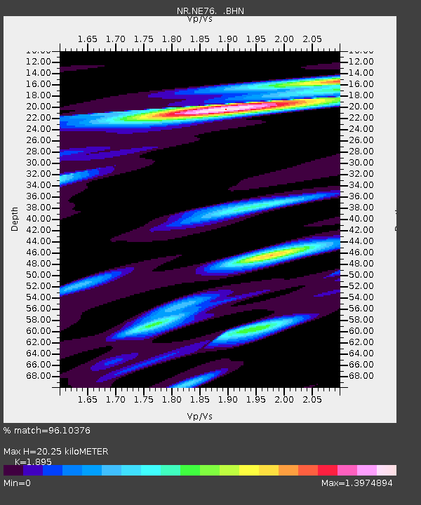
| Estimated Moho Depth: |
20.25 km |
| Estimated Crust Vp/Vs: |
1.89 |
| Assumed Crust Vp: |
6.183 km/s |
| Estimated Crust Vs: |
3.263 km/s |
| Estimated Crust Poisson's Ratio: |
0.31 |
|
| Radial Match: |
96.10376 % |
| Radial Bump: |
400 |
| Transverse Match: |
85.31959 % |
| Transverse Bump: |
400 |
| SOD ConfigId: |
5423 |
| Insert Time: |
2010-03-09 12:45:10.954 +0000 |
| GWidth: |
2.5 |
| Max Bumps: |
400 |
| Tol: |
0.001 |
|

Signal To Noise
| Channel | StoN | STA | LTA |
| NR:NE76: :BHN:20060516T10:51:18.879001Z | 0.7069885 | 2.3606842E-7 | 3.33907E-7 |
| NR:NE76: :BHE:20060516T10:51:18.879001Z | 0.8718474 | 3.1212647E-7 | 3.5800585E-7 |
| NR:NE76: :BHZ:20060516T10:51:18.879001Z | 2.4635417 | 4.9085503E-7 | 1.992477E-7 |
| Arrivals |
| Ps | 3.0 SECOND |
| PpPs | 9.3 SECOND |
| PsPs/PpSs | 12 SECOND |


