You are here: Home > Network List > KR - Kyrgyz Digital Network Stations List
> Station DRK Karamyk, Kyrgyzstan > Earthquake Result Viewer
DRK Karamyk, Kyrgyzstan - Earthquake Result Viewer
| Earthquake location: |
Off W Coast Of Northern Sumatra |
| Earthquake latitude/longitude: |
2.9/95.4 |
| Earthquake time(UTC): |
2021/09/14 (257) 20:13:54 GMT |
| Earthquake Depth: |
15 km |
| Earthquake Magnitude: |
5.3 Mww |
| Earthquake Catalog/Contributor: |
NEIC PDE/us |
|
| Network: |
KR Kyrgyz Digital Network |
| Station: |
DRK Karamyk, Kyrgyzstan |
| Lat/Lon: |
39.48 N/71.80 E |
| Elevation: |
2627 m |
|
| Distance: |
42.2 deg |
| Az: |
332.559 deg |
| Baz: |
143.511 deg |
| Ray Param: |
0.0733034 |
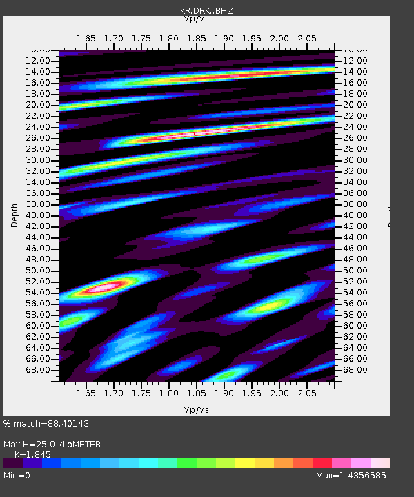
| Estimated Moho Depth: |
25.0 km |
| Estimated Crust Vp/Vs: |
1.85 |
| Assumed Crust Vp: |
6.306 km/s |
| Estimated Crust Vs: |
3.418 km/s |
| Estimated Crust Poisson's Ratio: |
0.29 |
|
| Radial Match: |
88.40143 % |
| Radial Bump: |
400 |
| Transverse Match: |
80.831276 % |
| Transverse Bump: |
400 |
| SOD ConfigId: |
25131211 |
| Insert Time: |
2021-09-28 20:19:52.961 +0000 |
| GWidth: |
2.5 |
| Max Bumps: |
400 |
| Tol: |
0.001 |
|

Signal To Noise
| Channel | StoN | STA | LTA |
| KR:DRK: :BHZ:20210914T20:21:15.779989Z | 13.436578 | 8.856413E-7 | 6.5912715E-8 |
| KR:DRK: :BHN:20210914T20:21:15.779989Z | 4.7901044 | 4.2952726E-7 | 8.9669705E-8 |
| KR:DRK: :BHE:20210914T20:21:15.779989Z | 4.510097 | 4.0711805E-7 | 9.026814E-8 |
| Arrivals |
| Ps | 3.6 SECOND |
| PpPs | 11 SECOND |
| PsPs/PpSs | 14 SECOND |


