You are here: Home > Network List > NR - NARS Array Stations List
> Station NE77 Loreto, Mexico > Earthquake Result Viewer
NE77 Loreto, Mexico - Earthquake Result Viewer
| Earthquake location: |
Eastern Honshu, Japan |
| Earthquake latitude/longitude: |
39.8/141.5 |
| Earthquake time(UTC): |
2008/07/23 (205) 15:26:19 GMT |
| Earthquake Depth: |
108 km |
| Earthquake Magnitude: |
6.6 MB, 6.8 MW, 6.8 MW |
| Earthquake Catalog/Contributor: |
WHDF/NEIC |
|
| Network: |
NR NARS Array |
| Station: |
NE77 Loreto, Mexico |
| Lat/Lon: |
26.02 N/111.36 W |
| Elevation: |
40 m |
|
| Distance: |
85.8 deg |
| Az: |
59.546 deg |
| Baz: |
312.438 deg |
| Ray Param: |
0.04428547 |
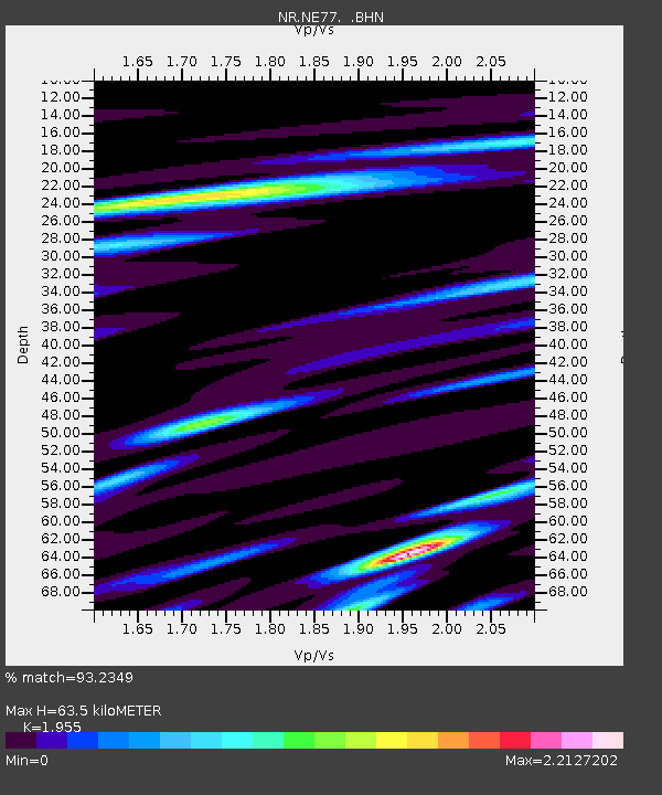
| Estimated Moho Depth: |
63.5 km |
| Estimated Crust Vp/Vs: |
1.96 |
| Assumed Crust Vp: |
6.183 km/s |
| Estimated Crust Vs: |
3.162 km/s |
| Estimated Crust Poisson's Ratio: |
0.32 |
|
| Radial Match: |
93.2349 % |
| Radial Bump: |
400 |
| Transverse Match: |
92.43726 % |
| Transverse Bump: |
400 |
| SOD ConfigId: |
2658 |
| Insert Time: |
2010-03-09 12:45:44.771 +0000 |
| GWidth: |
2.5 |
| Max Bumps: |
400 |
| Tol: |
0.001 |
|

Signal To Noise
| Channel | StoN | STA | LTA |
| NR:NE77: :BHN:20080723T15:38:16.080005Z | 19.854292 | 3.7244602E-6 | 1.8758969E-7 |
| NR:NE77: :BHE:20080723T15:38:16.080005Z | 3.6560726 | 8.1910633E-7 | 2.2403995E-7 |
| NR:NE77: :BHZ:20080723T15:38:16.080005Z | 2.9737282 | 7.4866585E-7 | 2.5176E-7 |
| Arrivals |
| Ps | 10 SECOND |
| PpPs | 30 SECOND |
| PsPs/PpSs | 40 SECOND |


