You are here: Home > Network List > NR - NARS Array Stations List
> Station NE77 Loreto, Mexico > Earthquake Result Viewer
NE77 Loreto, Mexico - Earthquake Result Viewer
| Earthquake location: |
Northern Peru |
| Earthquake latitude/longitude: |
-5.7/-76.4 |
| Earthquake time(UTC): |
2005/09/26 (269) 01:55:37 GMT |
| Earthquake Depth: |
115 km |
| Earthquake Magnitude: |
6.7 MB, 7.5 MW, 7.5 MW |
| Earthquake Catalog/Contributor: |
WHDF/NEIC |
|
| Network: |
NR NARS Array |
| Station: |
NE77 Loreto, Mexico |
| Lat/Lon: |
26.02 N/111.36 W |
| Elevation: |
40 m |
|
| Distance: |
46.3 deg |
| Az: |
314.493 deg |
| Baz: |
127.917 deg |
| Ray Param: |
0.07034085 |
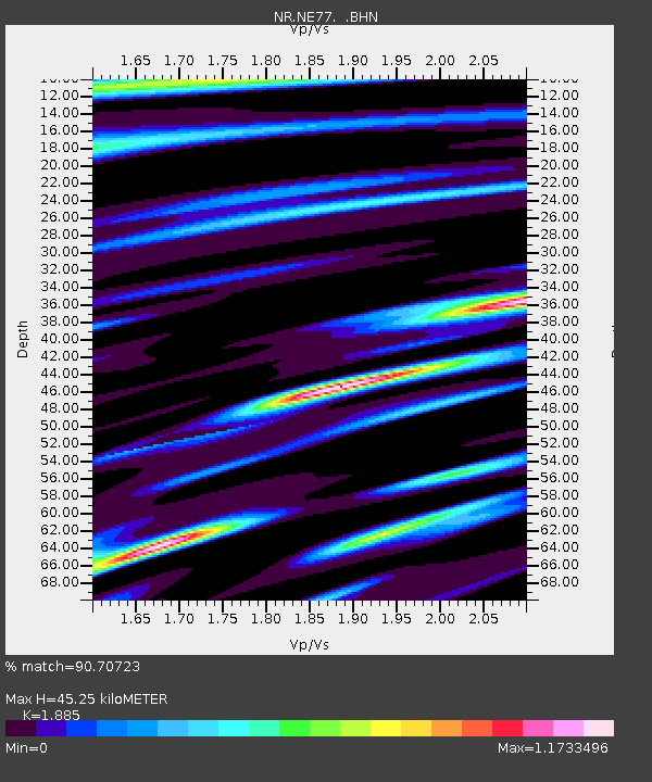
| Estimated Moho Depth: |
45.25 km |
| Estimated Crust Vp/Vs: |
1.88 |
| Assumed Crust Vp: |
6.183 km/s |
| Estimated Crust Vs: |
3.28 km/s |
| Estimated Crust Poisson's Ratio: |
0.30 |
|
| Radial Match: |
90.70723 % |
| Radial Bump: |
400 |
| Transverse Match: |
88.22381 % |
| Transverse Bump: |
400 |
| SOD ConfigId: |
2564 |
| Insert Time: |
2010-03-09 12:45:53.035 +0000 |
| GWidth: |
2.5 |
| Max Bumps: |
400 |
| Tol: |
0.001 |
|

Signal To Noise
| Channel | StoN | STA | LTA |
| NR:NE77: :BHN:20050926T02:03:21.275011Z | 12.002855 | 3.5763842E-6 | 2.9796112E-7 |
| NR:NE77: :BHE:20050926T02:03:21.275011Z | 15.7125025 | 6.1292017E-6 | 3.9008438E-7 |
| NR:NE77: :BHZ:20050926T02:03:21.275011Z | 39.858013 | 1.283476E-5 | 3.2201203E-7 |
| Arrivals |
| Ps | 6.8 SECOND |
| PpPs | 20 SECOND |
| PsPs/PpSs | 27 SECOND |


