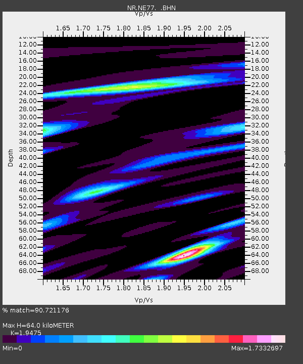
NE77 Loreto, Mexico - Earthquake Result Viewer

Earthquake location: Near East Coast Of Honshu, Japan
Earthquake latitude/longitude: 38.3/142.0
Earthquake time(UTC): 2005/08/16 (228) 02:46:28 GMT
Earthquake Depth: 36 km
Earthquake Magnitude: 6.5 MB, 6.8 MS, 7.2 MW, 7.1 MW
Earthquake Catalog/Contributor: WHDF/NEIC
Network: NR NARS Array
Station: NE77 Loreto, Mexico
Lat/Lon: 26.02 N/111.36 W
Elevation: 40 m
Distance: 86.2 deg
Az: 59.798 deg
Baz: 310.892 deg
Ray Param: 0.04419337
Estimated Moho Depth: 64.0 km
Estimated Crust Vp/Vs: 1.95
Assumed Crust Vp: 6.183 km/s
Estimated Crust Vs: 3.175 km/s
Estimated Crust Poisson's Ratio: 0.32
Radial Match: 90.721176 %
Radial Bump: 400
Transverse Match: 88.11282 %
Transverse Bump: 400
SOD ConfigId: 2564
Insert Time: 2010-03-09 12:45:56.260 +0000
GWidth: 2.5
Max Bumps: 400
Tol: 0.001

Signal To Noise

ChannelStoNSTALTA
NR:NE77: :BHN:20050816T02:58:34.70603Z2.2458493.456749E-71.5391726E-7
NR:NE77: :BHE:20050816T02:58:34.70603Z1.75545762.3454075E-71.3360662E-7
NR:NE77: :BHZ:20050816T02:58:34.70603Z4.49656255.936225E-71.3201696E-7
Arrivals
Ps10 SECOND
PpPs30 SECOND
PsPs/PpSs40 SECOND