You are here: Home > Network List > NR - NARS Array Stations List
> Station NE77 Loreto, Mexico > Earthquake Result Viewer
NE77 Loreto, Mexico - Earthquake Result Viewer
| Earthquake location: |
Fiji Islands Region |
| Earthquake latitude/longitude: |
-18.0/-179.6 |
| Earthquake time(UTC): |
2006/02/24 (055) 14:15:45 GMT |
| Earthquake Depth: |
622 km |
| Earthquake Magnitude: |
5.9 MB, 6.1 MW, 6.0 MW |
| Earthquake Catalog/Contributor: |
WHDF/NEIC |
|
| Network: |
NR NARS Array |
| Station: |
NE77 Loreto, Mexico |
| Lat/Lon: |
26.02 N/111.36 W |
| Elevation: |
40 m |
|
| Distance: |
79.4 deg |
| Az: |
58.223 deg |
| Baz: |
244.04 deg |
| Ray Param: |
0.047015388 |
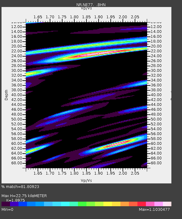
| Estimated Moho Depth: |
22.75 km |
| Estimated Crust Vp/Vs: |
1.90 |
| Assumed Crust Vp: |
6.183 km/s |
| Estimated Crust Vs: |
3.258 km/s |
| Estimated Crust Poisson's Ratio: |
0.31 |
|
| Radial Match: |
81.80923 % |
| Radial Bump: |
400 |
| Transverse Match: |
72.62327 % |
| Transverse Bump: |
385 |
| SOD ConfigId: |
5423 |
| Insert Time: |
2010-03-09 12:46:09.639 +0000 |
| GWidth: |
2.5 |
| Max Bumps: |
400 |
| Tol: |
0.001 |
|

Signal To Noise
| Channel | StoN | STA | LTA |
| NR:NE77: :BHN:20060224T14:26:17.267007Z | 2.0690744 | 5.0871614E-7 | 2.4586652E-7 |
| NR:NE77: :BHE:20060224T14:26:17.267007Z | 4.9754963 | 9.603085E-7 | 1.9300758E-7 |
| NR:NE77: :BHZ:20060224T14:26:17.267007Z | 16.599533 | 2.52671E-6 | 1.5221572E-7 |
| Arrivals |
| Ps | 3.4 SECOND |
| PpPs | 10 SECOND |
| PsPs/PpSs | 14 SECOND |


