You are here: Home > Network List > NR - NARS Array Stations List
> Station NE77 Loreto, Mexico > Earthquake Result Viewer
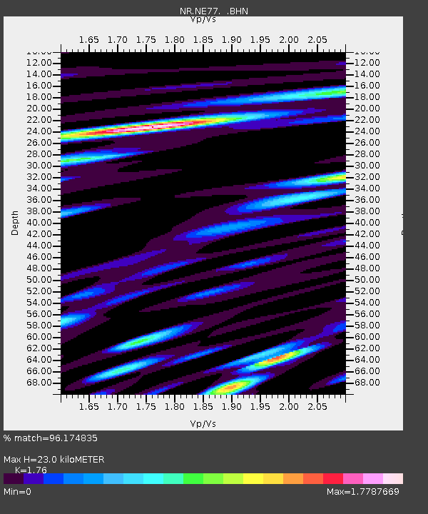
NE77 Loreto, Mexico - Earthquake Result Viewer
| Earthquake location: |
E. Russia-N.E. China Border Reg. |
| Earthquake latitude/longitude: |
43.8/130.7 |
| Earthquake time(UTC): |
2002/06/28 (179) 17:19:30 GMT |
| Earthquake Depth: |
566 km |
| Earthquake Magnitude: |
6.7 MB, 7.3 MW, 7.3 MW |
| Earthquake Catalog/Contributor: |
WHDF/NEIC |
|
| Network: |
NR NARS Array |
| Station: |
NE77 Loreto, Mexico |
| Lat/Lon: |
26.02 N/111.36 W |
| Elevation: |
40 m |
|
| Distance: |
90.3 deg |
| Az: |
52.628 deg |
| Baz: |
320.208 deg |
| Ray Param: |
0.04145682 |
| Estimated Moho Depth: |
23.0 km |
| Estimated Crust Vp/Vs: |
1.76 |
| Assumed Crust Vp: |
6.183 km/s |
| Estimated Crust Vs: |
3.513 km/s |
| Estimated Crust Poisson's Ratio: |
0.26 |
|
| Radial Match: |
96.174835 % |
| Radial Bump: |
400 |
| Transverse Match: |
91.85597 % |
| Transverse Bump: |
400 |
| SOD ConfigId: |
20082 |
| Insert Time: |
2010-03-09 12:46:13.777 +0000 |
| GWidth: |
2.5 |
| Max Bumps: |
400 |
| Tol: |
0.001 |
|

Signal To Noise
| Channel | StoN | STA | LTA |
| NR:NE77: :BHN:20020628T17:30:59.960002Z | 2.7481887 | 8.7057447E-7 | 3.1678115E-7 |
| NR:NE77: :BHE:20020628T17:30:59.960002Z | 2.0109117 | 5.720567E-7 | 2.8447627E-7 |
| NR:NE77: :BHZ:20020628T17:30:59.960002Z | 16.895704 | 3.6956185E-6 | 2.1873126E-7 |
| Arrivals |
| Ps | 2.9 SECOND |
| PpPs | 10 SECOND |
| PsPs/PpSs | 13 SECOND |


