You are here: Home > Network List > NR - NARS Array Stations List
> Station NE77 Loreto, Mexico > Earthquake Result Viewer
NE77 Loreto, Mexico - Earthquake Result Viewer
| Earthquake location: |
South Of Alaska |
| Earthquake latitude/longitude: |
53.8/-161.1 |
| Earthquake time(UTC): |
2002/05/25 (145) 05:36:31 GMT |
| Earthquake Depth: |
33 km |
| Earthquake Magnitude: |
5.5 MB, 6.1 MS, 6.5 MW, 6.4 MW |
| Earthquake Catalog/Contributor: |
WHDF/NEIC |
|
| Network: |
NR NARS Array |
| Station: |
NE77 Loreto, Mexico |
| Lat/Lon: |
26.02 N/111.36 W |
| Elevation: |
40 m |
|
| Distance: |
45.9 deg |
| Az: |
106.958 deg |
| Baz: |
320.925 deg |
| Ray Param: |
0.07091844 |
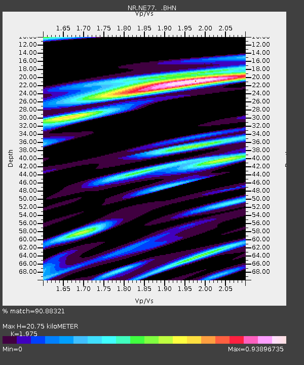
| Estimated Moho Depth: |
20.75 km |
| Estimated Crust Vp/Vs: |
1.98 |
| Assumed Crust Vp: |
6.183 km/s |
| Estimated Crust Vs: |
3.13 km/s |
| Estimated Crust Poisson's Ratio: |
0.33 |
|
| Radial Match: |
90.88321 % |
| Radial Bump: |
400 |
| Transverse Match: |
80.024216 % |
| Transverse Bump: |
400 |
| SOD ConfigId: |
20082 |
| Insert Time: |
2010-03-09 12:46:19.284 +0000 |
| GWidth: |
2.5 |
| Max Bumps: |
400 |
| Tol: |
0.001 |
|

Signal To Noise
| Channel | StoN | STA | LTA |
| NR:NE77: :BHN:20020525T05:44:20.760009Z | 0.9590008 | 1.2545146E-7 | 1.3081475E-7 |
| NR:NE77: :BHE:20020525T05:44:20.760009Z | 0.6957861 | 1.6316893E-7 | 2.345102E-7 |
| NR:NE77: :BHZ:20020525T05:44:20.760009Z | 3.9519753 | 3.8014517E-7 | 9.619117E-8 |
| Arrivals |
| Ps | 3.4 SECOND |
| PpPs | 9.5 SECOND |
| PsPs/PpSs | 13 SECOND |


