You are here: Home > Network List > AU - Australian Seismological Centre Stations List
> Station PSAA2 Pilbara Seismic Array Element A2 > Earthquake Result Viewer
PSAA2 Pilbara Seismic Array Element A2 - Earthquake Result Viewer
| Earthquake location: |
New Ireland Region, P.N.G. |
| Earthquake latitude/longitude: |
-4.3/153.3 |
| Earthquake time(UTC): |
2018/03/09 (068) 11:06:10 GMT |
| Earthquake Depth: |
46 km |
| Earthquake Magnitude: |
5.8 Mww |
| Earthquake Catalog/Contributor: |
NEIC PDE/us |
|
| Network: |
AU Australian Seismological Centre |
| Station: |
PSAA2 Pilbara Seismic Array Element A2 |
| Lat/Lon: |
21.56 S/119.85 E |
| Elevation: |
330 m |
|
| Distance: |
36.7 deg |
| Az: |
239.225 deg |
| Baz: |
66.982 deg |
| Ray Param: |
0.076421574 |
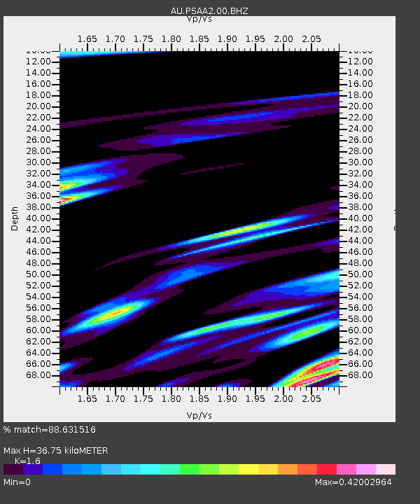
| Estimated Moho Depth: |
36.75 km |
| Estimated Crust Vp/Vs: |
1.60 |
| Assumed Crust Vp: |
6.464 km/s |
| Estimated Crust Vs: |
4.04 km/s |
| Estimated Crust Poisson's Ratio: |
0.18 |
|
| Radial Match: |
88.631516 % |
| Radial Bump: |
400 |
| Transverse Match: |
62.020058 % |
| Transverse Bump: |
400 |
| SOD ConfigId: |
2615551 |
| Insert Time: |
2018-03-23 11:06:50.077 +0000 |
| GWidth: |
2.5 |
| Max Bumps: |
400 |
| Tol: |
0.001 |
|

Signal To Noise
| Channel | StoN | STA | LTA |
| AU:PSAA2:00:BHZ:20180309T11:12:42.818989Z | 13.2901535 | 2.4292033E-6 | 1.8278219E-7 |
| AU:PSAA2:00:BH1:20180309T11:12:42.818989Z | 14.732071 | 1.3751445E-6 | 9.3343594E-8 |
| AU:PSAA2:00:BH2:20180309T11:12:42.818989Z | 7.3916507 | 8.1508216E-7 | 1.10270655E-7 |
| Arrivals |
| Ps | 3.7 SECOND |
| PpPs | 14 SECOND |
| PsPs/PpSs | 17 SECOND |


