You are here: Home > Network List > NR - NARS Array Stations List
> Station NE78 Las Pocitas, Mexico > Earthquake Result Viewer
NE78 Las Pocitas, Mexico - Earthquake Result Viewer
| Earthquake location: |
Northwest Of Kuril Islands |
| Earthquake latitude/longitude: |
47.8/146.2 |
| Earthquake time(UTC): |
2002/11/17 (321) 04:53:53 GMT |
| Earthquake Depth: |
459 km |
| Earthquake Magnitude: |
7.3 MW, 7.3 MW |
| Earthquake Catalog/Contributor: |
WHDF/NEIC |
|
| Network: |
NR NARS Array |
| Station: |
NE78 Las Pocitas, Mexico |
| Lat/Lon: |
24.40 N/111.11 W |
| Elevation: |
82 m |
|
| Distance: |
80.3 deg |
| Az: |
64.475 deg |
| Baz: |
318.165 deg |
| Ray Param: |
0.04705416 |
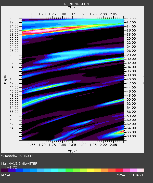
| Estimated Moho Depth: |
15.5 km |
| Estimated Crust Vp/Vs: |
1.72 |
| Assumed Crust Vp: |
6.182 km/s |
| Estimated Crust Vs: |
3.594 km/s |
| Estimated Crust Poisson's Ratio: |
0.24 |
|
| Radial Match: |
86.36087 % |
| Radial Bump: |
375 |
| Transverse Match: |
66.92242 % |
| Transverse Bump: |
400 |
| SOD ConfigId: |
4714 |
| Insert Time: |
2010-03-09 12:46:47.852 +0000 |
| GWidth: |
2.5 |
| Max Bumps: |
400 |
| Tol: |
0.001 |
|

Signal To Noise
| Channel | StoN | STA | LTA |
| NR:NE78: :BHN:20021117T05:04:44.508994Z | 7.8085814 | 8.353056E-6 | 1.0697278E-6 |
| NR:NE78: :BHE:20021117T05:04:44.508994Z | 1.9544175 | 2.3491862E-6 | 1.201988E-6 |
| NR:NE78: :BHZ:20021117T05:04:44.508994Z | 37.20868 | 4.093776E-5 | 1.1002207E-6 |
| Arrivals |
| Ps | 1.9 SECOND |
| PpPs | 6.6 SECOND |
| PsPs/PpSs | 8.5 SECOND |


