You are here: Home > Network List > CI - Caltech Regional Seismic Network Stations List
> Station SWS Sam W. Stewart, Westmorland, CA, USA > Earthquake Result Viewer
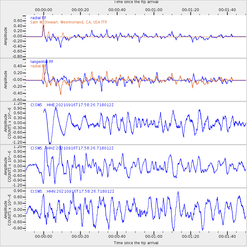
SWS Sam W. Stewart, Westmorland, CA, USA - Earthquake Result Viewer
*The percent match for this event was below the threshold and hence no stack was calculated.
| Earthquake location: |
South Of Alaska |
| Earthquake latitude/longitude: |
55.2/-156.7 |
| Earthquake time(UTC): |
2021/09/16 (259) 17:51:54 GMT |
| Earthquake Depth: |
0.0 km |
| Earthquake Magnitude: |
5.6 Mww |
| Earthquake Catalog/Contributor: |
NEIC PDE/ak |
|
| Network: |
CI Caltech Regional Seismic Network |
| Station: |
SWS Sam W. Stewart, Westmorland, CA, USA |
| Lat/Lon: |
32.94 N/115.80 W |
| Elevation: |
140 m |
|
| Distance: |
36.1 deg |
| Az: |
111.027 deg |
| Baz: |
320.528 deg |
| Ray Param: |
$rayparam |
*The percent match for this event was below the threshold and hence was not used in the summary stack. |
|
| Radial Match: |
59.115967 % |
| Radial Bump: |
400 |
| Transverse Match: |
68.919464 % |
| Transverse Bump: |
371 |
| SOD ConfigId: |
25131211 |
| Insert Time: |
2021-09-30 17:56:04.214 +0000 |
| GWidth: |
2.5 |
| Max Bumps: |
400 |
| Tol: |
0.001 |
|
Signal To Noise
| Channel | StoN | STA | LTA |
| CI:SWS: :HHZ:20210916T17:58:26.718012Z | 2.565923 | 7.0067557E-7 | 2.730696E-7 |
| CI:SWS: :HHN:20210916T17:58:26.718012Z | 1.6129341 | 3.7409205E-7 | 2.3193263E-7 |
| CI:SWS: :HHE:20210916T17:58:26.718012Z | 0.553097 | 2.95544E-7 | 5.343439E-7 |
| Arrivals |
| Ps | |
| PpPs | |
| PsPs/PpSs | |


