You are here: Home > Network List > NR - NARS Array Stations List
> Station NE80 Caborca, Mexico > Earthquake Result Viewer
NE80 Caborca, Mexico - Earthquake Result Viewer
| Earthquake location: |
East Of Kuril Islands |
| Earthquake latitude/longitude: |
44.0/151.4 |
| Earthquake time(UTC): |
2004/09/13 (257) 03:00:12 GMT |
| Earthquake Depth: |
8.0 km |
| Earthquake Magnitude: |
6.0 MB, 5.4 MS, 6.1 MW, 5.9 MW |
| Earthquake Catalog/Contributor: |
WHDF/NEIC |
|
| Network: |
NR NARS Array |
| Station: |
NE80 Caborca, Mexico |
| Lat/Lon: |
30.50 N/112.32 W |
| Elevation: |
225 m |
|
| Distance: |
73.6 deg |
| Az: |
63.394 deg |
| Baz: |
311.616 deg |
| Ray Param: |
0.05286751 |
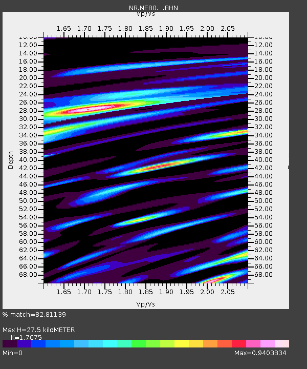
| Estimated Moho Depth: |
27.5 km |
| Estimated Crust Vp/Vs: |
1.71 |
| Assumed Crust Vp: |
6.276 km/s |
| Estimated Crust Vs: |
3.675 km/s |
| Estimated Crust Poisson's Ratio: |
0.24 |
|
| Radial Match: |
82.81139 % |
| Radial Bump: |
400 |
| Transverse Match: |
68.09493 % |
| Transverse Bump: |
400 |
| SOD ConfigId: |
2459 |
| Insert Time: |
2010-03-09 12:47:24.978 +0000 |
| GWidth: |
2.5 |
| Max Bumps: |
400 |
| Tol: |
0.001 |
|

Signal To Noise
| Channel | StoN | STA | LTA |
| NR:NE80: :BHN:20040913T03:11:15.482996Z | 4.181715 | 4.4640146E-7 | 1.0675081E-7 |
| NR:NE80: :BHE:20040913T03:11:15.482996Z | 5.4644747 | 4.4901276E-7 | 8.216943E-8 |
| NR:NE80: :BHZ:20040913T03:11:15.482996Z | 9.837306 | 1.0820036E-6 | 1.0998982E-7 |
| Arrivals |
| Ps | 3.2 SECOND |
| PpPs | 11 SECOND |
| PsPs/PpSs | 15 SECOND |


