You are here: Home > Network List > TX - Texas Seismological Network Stations List
> Station 833A Chaparral WMA, Artesia Wells, TX, USA > Earthquake Result Viewer
833A Chaparral WMA, Artesia Wells, TX, USA - Earthquake Result Viewer
| Earthquake location: |
South Of Alaska |
| Earthquake latitude/longitude: |
55.2/-156.7 |
| Earthquake time(UTC): |
2021/09/16 (259) 17:51:54 GMT |
| Earthquake Depth: |
0.0 km |
| Earthquake Magnitude: |
5.6 Mww |
| Earthquake Catalog/Contributor: |
NEIC PDE/ak |
|
| Network: |
TX Texas Seismological Network |
| Station: |
833A Chaparral WMA, Artesia Wells, TX, USA |
| Lat/Lon: |
28.32 N/99.39 W |
| Elevation: |
171 m |
|
| Distance: |
48.7 deg |
| Az: |
99.237 deg |
| Baz: |
320.121 deg |
| Ray Param: |
0.06922046 |
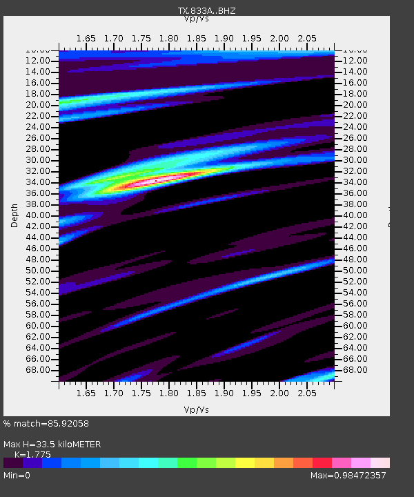
| Estimated Moho Depth: |
33.5 km |
| Estimated Crust Vp/Vs: |
1.77 |
| Assumed Crust Vp: |
6.347 km/s |
| Estimated Crust Vs: |
3.576 km/s |
| Estimated Crust Poisson's Ratio: |
0.27 |
|
| Radial Match: |
85.92058 % |
| Radial Bump: |
307 |
| Transverse Match: |
78.27247 % |
| Transverse Bump: |
400 |
| SOD ConfigId: |
25131211 |
| Insert Time: |
2021-09-30 18:10:01.030 +0000 |
| GWidth: |
2.5 |
| Max Bumps: |
400 |
| Tol: |
0.001 |
|

Signal To Noise
| Channel | StoN | STA | LTA |
| TX:833A: :BHZ:20210916T18:00:09.073999Z | 2.71759 | 4.8453217E-7 | 1.782948E-7 |
| TX:833A: :BHN:20210916T18:00:09.073999Z | 1.4790958 | 1.5487937E-7 | 1.047122E-7 |
| TX:833A: :BHE:20210916T18:00:09.073999Z | 2.7455678 | 3.3228991E-7 | 1.2102775E-7 |
| Arrivals |
| Ps | 4.3 SECOND |
| PpPs | 14 SECOND |
| PsPs/PpSs | 18 SECOND |


