You are here: Home > Network List > US - United States National Seismic Network Stations List
> Station AMTX Amarillo, Texas, USA > Earthquake Result Viewer
AMTX Amarillo, Texas, USA - Earthquake Result Viewer
*The percent match for this event was below the threshold and hence no stack was calculated.
| Earthquake location: |
South Of Alaska |
| Earthquake latitude/longitude: |
55.2/-156.7 |
| Earthquake time(UTC): |
2021/09/16 (259) 17:51:54 GMT |
| Earthquake Depth: |
0.0 km |
| Earthquake Magnitude: |
5.6 Mww |
| Earthquake Catalog/Contributor: |
NEIC PDE/ak |
|
| Network: |
US United States National Seismic Network |
| Station: |
AMTX Amarillo, Texas, USA |
| Lat/Lon: |
34.53 N/101.41 W |
| Elevation: |
1010 m |
|
| Distance: |
42.9 deg |
| Az: |
95.281 deg |
| Baz: |
316.313 deg |
| Ray Param: |
$rayparam |
*The percent match for this event was below the threshold and hence was not used in the summary stack. |
|
| Radial Match: |
35.714462 % |
| Radial Bump: |
400 |
| Transverse Match: |
68.45063 % |
| Transverse Bump: |
400 |
| SOD ConfigId: |
25131211 |
| Insert Time: |
2021-09-30 18:11:19.872 +0000 |
| GWidth: |
2.5 |
| Max Bumps: |
400 |
| Tol: |
0.001 |
|
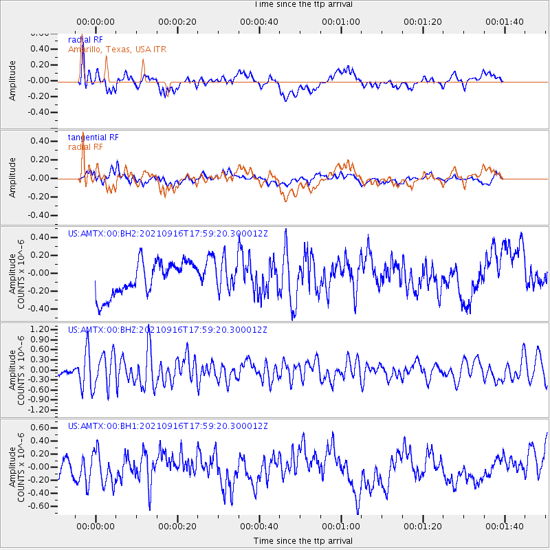
Signal To Noise
| Channel | StoN | STA | LTA |
| US:AMTX:00:BHZ:20210916T17:59:20.300012Z | 2.7406704 | 5.194976E-7 | 1.8955129E-7 |
| US:AMTX:00:BH1:20210916T17:59:20.300012Z | 1.2030083 | 2.5210593E-7 | 2.0956291E-7 |
| US:AMTX:00:BH2:20210916T17:59:20.300012Z | 1.2764513 | 1.9043033E-7 | 1.491873E-7 |
| Arrivals |
| Ps | |
| PpPs | |
| PsPs/PpSs | |


