You are here: Home > Network List > US - United States National Seismic Network Stations List
> Station MIAR Mount Ida, Arkansas, USA > Earthquake Result Viewer
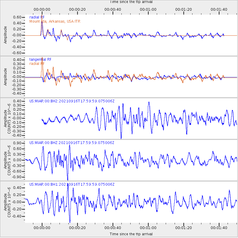
MIAR Mount Ida, Arkansas, USA - Earthquake Result Viewer
*The percent match for this event was below the threshold and hence no stack was calculated.
| Earthquake location: |
South Of Alaska |
| Earthquake latitude/longitude: |
55.2/-156.7 |
| Earthquake time(UTC): |
2021/09/16 (259) 17:51:54 GMT |
| Earthquake Depth: |
0.0 km |
| Earthquake Magnitude: |
5.6 Mww |
| Earthquake Catalog/Contributor: |
NEIC PDE/ak |
|
| Network: |
US United States National Seismic Network |
| Station: |
MIAR Mount Ida, Arkansas, USA |
| Lat/Lon: |
34.55 N/93.58 W |
| Elevation: |
207 m |
|
| Distance: |
47.4 deg |
| Az: |
88.688 deg |
| Baz: |
316.083 deg |
| Ray Param: |
$rayparam |
*The percent match for this event was below the threshold and hence was not used in the summary stack. |
|
| Radial Match: |
72.76765 % |
| Radial Bump: |
400 |
| Transverse Match: |
62.42164 % |
| Transverse Bump: |
400 |
| SOD ConfigId: |
25131211 |
| Insert Time: |
2021-09-30 18:11:38.945 +0000 |
| GWidth: |
2.5 |
| Max Bumps: |
400 |
| Tol: |
0.001 |
|
Signal To Noise
| Channel | StoN | STA | LTA |
| US:MIAR:00:BHZ:20210916T17:59:59.075006Z | 4.574315 | 4.166905E-7 | 9.109353E-8 |
| US:MIAR:00:BH1:20210916T17:59:59.075006Z | 2.2322745 | 1.8933987E-7 | 8.4819256E-8 |
| US:MIAR:00:BH2:20210916T17:59:59.075006Z | 3.405733 | 1.8791195E-7 | 5.517518E-8 |
| Arrivals |
| Ps | |
| PpPs | |
| PsPs/PpSs | |


