You are here: Home > Network List > AK - Alaska Regional Network Stations List
> Station BMR Bremner River > Earthquake Result Viewer
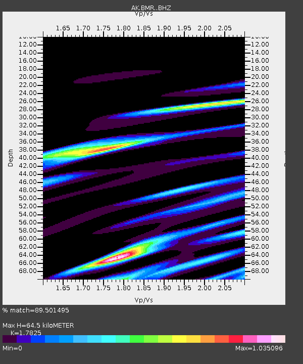
BMR Bremner River - Earthquake Result Viewer
| Earthquake location: |
Vanuatu Islands |
| Earthquake latitude/longitude: |
-13.4/167.4 |
| Earthquake time(UTC): |
2021/09/17 (260) 10:28:40 GMT |
| Earthquake Depth: |
10 km |
| Earthquake Magnitude: |
5.8 mww |
| Earthquake Catalog/Contributor: |
NEIC PDE/us |
|
| Network: |
AK Alaska Regional Network |
| Station: |
BMR Bremner River |
| Lat/Lon: |
60.97 N/144.60 W |
| Elevation: |
842 m |
|
| Distance: |
83.3 deg |
| Az: |
21.401 deg |
| Baz: |
226.708 deg |
| Ray Param: |
0.046270188 |
| Estimated Moho Depth: |
64.5 km |
| Estimated Crust Vp/Vs: |
1.78 |
| Assumed Crust Vp: |
6.566 km/s |
| Estimated Crust Vs: |
3.684 km/s |
| Estimated Crust Poisson's Ratio: |
0.27 |
|
| Radial Match: |
89.501495 % |
| Radial Bump: |
372 |
| Transverse Match: |
57.869373 % |
| Transverse Bump: |
400 |
| SOD ConfigId: |
25131211 |
| Insert Time: |
2021-10-01 10:29:55.272 +0000 |
| GWidth: |
2.5 |
| Max Bumps: |
400 |
| Tol: |
0.001 |
|

Signal To Noise
| Channel | StoN | STA | LTA |
| AK:BMR: :BHZ:20210917T10:40:36.188015Z | 3.4345453 | 1.9001177E-6 | 5.5323704E-7 |
| AK:BMR: :BHN:20210917T10:40:36.188015Z | 2.9223776 | 1.2990721E-6 | 4.4452577E-7 |
| AK:BMR: :BHE:20210917T10:40:36.188015Z | 0.9147725 | 1.0544779E-6 | 1.1527216E-6 |
| Arrivals |
| Ps | 7.9 SECOND |
| PpPs | 27 SECOND |
| PsPs/PpSs | 35 SECOND |


