You are here: Home > Network List > NR - NARS Array Stations List
> Station NE82 Navajoa, Mexico > Earthquake Result Viewer
NE82 Navajoa, Mexico - Earthquake Result Viewer
| Earthquake location: |
Southern Bolivia |
| Earthquake latitude/longitude: |
-21.1/-65.6 |
| Earthquake time(UTC): |
2004/03/17 (077) 03:21:07 GMT |
| Earthquake Depth: |
290 km |
| Earthquake Magnitude: |
5.5 MB, 6.1 MW, 6.1 MW |
| Earthquake Catalog/Contributor: |
WHDF/NEIC |
|
| Network: |
NR NARS Array |
| Station: |
NE82 Navajoa, Mexico |
| Lat/Lon: |
26.92 N/109.23 W |
| Elevation: |
183 m |
|
| Distance: |
63.8 deg |
| Az: |
316.606 deg |
| Baz: |
134.08 deg |
| Ray Param: |
0.058433365 |
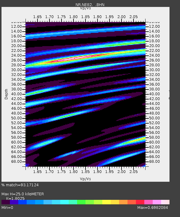
| Estimated Moho Depth: |
25.0 km |
| Estimated Crust Vp/Vs: |
1.80 |
| Assumed Crust Vp: |
6.155 km/s |
| Estimated Crust Vs: |
3.414 km/s |
| Estimated Crust Poisson's Ratio: |
0.28 |
|
| Radial Match: |
93.17124 % |
| Radial Bump: |
381 |
| Transverse Match: |
73.195175 % |
| Transverse Bump: |
400 |
| SOD ConfigId: |
2459 |
| Insert Time: |
2010-03-09 12:49:37.176 +0000 |
| GWidth: |
2.5 |
| Max Bumps: |
400 |
| Tol: |
0.001 |
|

Signal To Noise
| Channel | StoN | STA | LTA |
| NR:NE82: :BHN:20040317T03:30:38.524014Z | 6.703356 | 6.636705E-7 | 9.900571E-8 |
| NR:NE82: :BHE:20040317T03:30:38.524014Z | 9.489191 | 6.933112E-7 | 7.306326E-8 |
| NR:NE82: :BHZ:20040317T03:30:38.524014Z | 19.652525 | 2.240844E-6 | 1.1402321E-7 |
| Arrivals |
| Ps | 3.4 SECOND |
| PpPs | 11 SECOND |
| PsPs/PpSs | 14 SECOND |


