You are here: Home > Network List > NR - NARS Array Stations List
> Station NE82 Navajoa, Mexico > Earthquake Result Viewer
NE82 Navajoa, Mexico - Earthquake Result Viewer
| Earthquake location: |
Tonga Islands |
| Earthquake latitude/longitude: |
-16.8/-174.2 |
| Earthquake time(UTC): |
2004/01/25 (025) 11:43:11 GMT |
| Earthquake Depth: |
130 km |
| Earthquake Magnitude: |
6.4 MB, 6.7 MW, 6.7 MW |
| Earthquake Catalog/Contributor: |
WHDF/NEIC |
|
| Network: |
NR NARS Array |
| Station: |
NE82 Navajoa, Mexico |
| Lat/Lon: |
26.92 N/109.23 W |
| Elevation: |
183 m |
|
| Distance: |
76.6 deg |
| Az: |
56.28 deg |
| Baz: |
243.142 deg |
| Ray Param: |
0.050594393 |
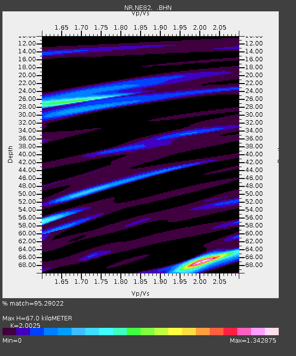
| Estimated Moho Depth: |
67.0 km |
| Estimated Crust Vp/Vs: |
2.00 |
| Assumed Crust Vp: |
6.155 km/s |
| Estimated Crust Vs: |
3.073 km/s |
| Estimated Crust Poisson's Ratio: |
0.33 |
|
| Radial Match: |
95.29022 % |
| Radial Bump: |
331 |
| Transverse Match: |
83.526115 % |
| Transverse Bump: |
400 |
| SOD ConfigId: |
2459 |
| Insert Time: |
2010-03-09 12:49:39.565 +0000 |
| GWidth: |
2.5 |
| Max Bumps: |
400 |
| Tol: |
0.001 |
|

Signal To Noise
| Channel | StoN | STA | LTA |
| NR:NE82: :BHN:20040125T11:54:16.948003Z | 3.9892218 | 2.9945363E-7 | 7.506568E-8 |
| NR:NE82: :BHE:20040125T11:54:16.948003Z | 4.775297 | 5.8101193E-7 | 1.2167031E-7 |
| NR:NE82: :BHZ:20040125T11:54:16.948003Z | 11.682516 | 1.4804336E-6 | 1.2672216E-7 |
| Arrivals |
| Ps | 11 SECOND |
| PpPs | 32 SECOND |
| PsPs/PpSs | 43 SECOND |


