You are here: Home > Network List > NR - NARS Array Stations List
> Station NE82 Navajoa, Mexico > Earthquake Result Viewer
NE82 Navajoa, Mexico - Earthquake Result Viewer
| Earthquake location: |
Mariana Islands |
| Earthquake latitude/longitude: |
21.0/144.7 |
| Earthquake time(UTC): |
2007/01/30 (030) 21:37:45 GMT |
| Earthquake Depth: |
30 km |
| Earthquake Magnitude: |
6.3 MB, 6.5 MS, 6.6 MW, 6.5 MW |
| Earthquake Catalog/Contributor: |
WHDF/NEIC |
|
| Network: |
NR NARS Array |
| Station: |
NE82 Navajoa, Mexico |
| Lat/Lon: |
26.92 N/109.23 W |
| Elevation: |
183 m |
|
| Distance: |
94.1 deg |
| Az: |
59.333 deg |
| Baz: |
295.816 deg |
| Ray Param: |
0.041122213 |
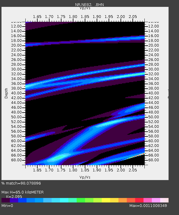
| Estimated Moho Depth: |
65.0 km |
| Estimated Crust Vp/Vs: |
2.10 |
| Assumed Crust Vp: |
6.155 km/s |
| Estimated Crust Vs: |
2.938 km/s |
| Estimated Crust Poisson's Ratio: |
0.35 |
|
| Radial Match: |
98.078896 % |
| Radial Bump: |
81 |
| Transverse Match: |
99.92925 % |
| Transverse Bump: |
9 |
| SOD ConfigId: |
2564 |
| Insert Time: |
2010-03-09 12:49:58.790 +0000 |
| GWidth: |
2.5 |
| Max Bumps: |
400 |
| Tol: |
0.001 |
|

Signal To Noise
| Channel | StoN | STA | LTA |
| NR:NE82: :BHN:20070130T21:50:29.741011Z | 0.21612091 | 1.5410217E-6 | 7.130368E-6 |
| NR:NE82: :BHE:20070130T21:50:29.741011Z | 0.21677864 | 8.9227973E-7 | 4.116087E-6 |
| NR:NE82: :BHZ:20070130T21:50:29.741011Z | 0.25237253 | 1.4326987E-6 | 5.6769204E-6 |
| Arrivals |
| Ps | 12 SECOND |
| PpPs | 32 SECOND |
| PsPs/PpSs | 44 SECOND |


