You are here: Home > Network List > GT - Global Telemetered Seismograph Network (USAF/USGS) Stations List
> Station LPAZ La Paz , Bolivia > Earthquake Result Viewer
LPAZ La Paz , Bolivia - Earthquake Result Viewer
| Earthquake location: |
South Sandwich Islands Region |
| Earthquake latitude/longitude: |
-56.3/-28.1 |
| Earthquake time(UTC): |
2018/03/10 (069) 14:27:56 GMT |
| Earthquake Depth: |
50 km |
| Earthquake Magnitude: |
5.6 Mww |
| Earthquake Catalog/Contributor: |
NEIC PDE/us |
|
| Network: |
GT Global Telemetered Seismograph Network (USAF/USGS) |
| Station: |
LPAZ La Paz , Bolivia |
| Lat/Lon: |
16.17 S/68.08 W |
| Elevation: |
4817 m |
|
| Distance: |
50.2 deg |
| Az: |
306.467 deg |
| Baz: |
152.192 deg |
| Ray Param: |
0.068082444 |
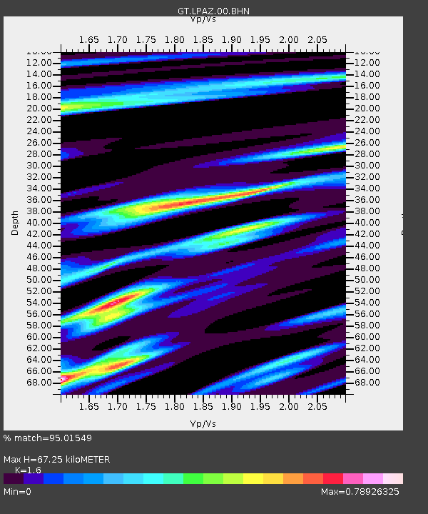
| Estimated Moho Depth: |
67.25 km |
| Estimated Crust Vp/Vs: |
1.60 |
| Assumed Crust Vp: |
6.454 km/s |
| Estimated Crust Vs: |
4.034 km/s |
| Estimated Crust Poisson's Ratio: |
0.18 |
|
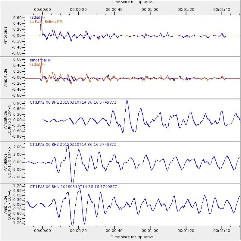
| Radial Match: |
95.01549 % |
| Radial Bump: |
397 |
| Transverse Match: |
81.466644 % |
| Transverse Bump: |
400 |
| SOD ConfigId: |
2615551 |
| Insert Time: |
2018-03-24 14:29:29.506 +0000 |
| GWidth: |
2.5 |
| Max Bumps: |
400 |
| Tol: |
0.001 |
|
Signal To Noise
| Channel | StoN | STA | LTA |
| GT:LPAZ:00:BHZ:20180310T14:36:16.574987Z | 0.52458966 | 6.063438E-8 | 1.155844E-7 |
| GT:LPAZ:00:BHN:20180310T14:36:16.574987Z | 1.1185175 | 8.7928406E-8 | 7.8611556E-8 |
| GT:LPAZ:00:BHE:20180310T14:36:16.574987Z | 0.98534656 | 9.267405E-8 | 9.405224E-8 |
| Arrivals |
| Ps | 6.7 SECOND |
| PpPs | 25 SECOND |
| PsPs/PpSs | 32 SECOND |


