You are here: Home > Network List > CN - Canadian National Seismograph Network Stations List
> Station INK INUVIK, NT > Earthquake Result Viewer
INK INUVIK, NT - Earthquake Result Viewer
*The percent match for this event was below the threshold and hence no stack was calculated.
| Earthquake location: |
Tonga Islands |
| Earthquake latitude/longitude: |
-21.1/-173.8 |
| Earthquake time(UTC): |
2021/09/20 (263) 18:34:48 GMT |
| Earthquake Depth: |
10 km |
| Earthquake Magnitude: |
5.8 Mww |
| Earthquake Catalog/Contributor: |
NEIC PDE/us |
|
| Network: |
CN Canadian National Seismograph Network |
| Station: |
INK INUVIK, NT |
| Lat/Lon: |
68.31 N/133.53 W |
| Elevation: |
44 m |
|
| Distance: |
93.8 deg |
| Az: |
13.932 deg |
| Baz: |
217.213 deg |
| Ray Param: |
$rayparam |
*The percent match for this event was below the threshold and hence was not used in the summary stack. |
|
| Radial Match: |
55.51612 % |
| Radial Bump: |
300 |
| Transverse Match: |
66.33297 % |
| Transverse Bump: |
400 |
| SOD ConfigId: |
25131211 |
| Insert Time: |
2021-10-04 18:42:53.506 +0000 |
| GWidth: |
2.5 |
| Max Bumps: |
400 |
| Tol: |
0.001 |
|
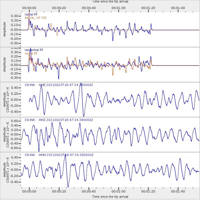
Signal To Noise
| Channel | StoN | STA | LTA |
| CN:INK: :HHZ:20210920T18:47:34.380009Z | 1.4353108 | 2.870734E-7 | 2.0000782E-7 |
| CN:INK: :HHN:20210920T18:47:34.380009Z | 0.8755586 | 1.6926842E-7 | 1.9332619E-7 |
| CN:INK: :HHE:20210920T18:47:34.380009Z | 1.7631147 | 3.2034083E-7 | 1.816903E-7 |
| Arrivals |
| Ps | |
| PpPs | |
| PsPs/PpSs | |


