You are here: Home > Network List > US - United States National Seismic Network Stations List
> Station EGMT Eagleton, Montana, USA > Earthquake Result Viewer
EGMT Eagleton, Montana, USA - Earthquake Result Viewer
*The percent match for this event was below the threshold and hence no stack was calculated.
| Earthquake location: |
Tonga Islands |
| Earthquake latitude/longitude: |
-21.1/-173.8 |
| Earthquake time(UTC): |
2021/09/20 (263) 18:34:48 GMT |
| Earthquake Depth: |
10 km |
| Earthquake Magnitude: |
5.8 Mww |
| Earthquake Catalog/Contributor: |
NEIC PDE/us |
|
| Network: |
US United States National Seismic Network |
| Station: |
EGMT Eagleton, Montana, USA |
| Lat/Lon: |
48.02 N/109.75 W |
| Elevation: |
1055 m |
|
| Distance: |
89.5 deg |
| Az: |
37.122 deg |
| Baz: |
237.092 deg |
| Ray Param: |
$rayparam |
*The percent match for this event was below the threshold and hence was not used in the summary stack. |
|
| Radial Match: |
51.22242 % |
| Radial Bump: |
400 |
| Transverse Match: |
34.42031 % |
| Transverse Bump: |
400 |
| SOD ConfigId: |
25131211 |
| Insert Time: |
2021-10-04 18:51:02.006 +0000 |
| GWidth: |
2.5 |
| Max Bumps: |
400 |
| Tol: |
0.001 |
|
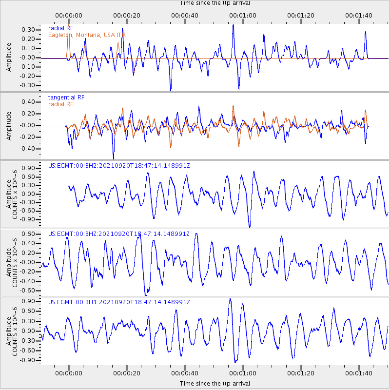
Signal To Noise
| Channel | StoN | STA | LTA |
| US:EGMT:00:BHZ:20210920T18:47:14.148991Z | 2.1576242 | 3.884084E-7 | 1.8001671E-7 |
| US:EGMT:00:BH1:20210920T18:47:14.148991Z | 2.0879402 | 3.730486E-7 | 1.7866823E-7 |
| US:EGMT:00:BH2:20210920T18:47:14.148991Z | 1.9072435 | 4.368974E-7 | 2.2907271E-7 |
| Arrivals |
| Ps | |
| PpPs | |
| PsPs/PpSs | |


