You are here: Home > Network List > GS - US Geological Survey Networks Stations List
> Station DEC06 Boomer > Earthquake Result Viewer
DEC06 Boomer - Earthquake Result Viewer
*The percent match for this event was below the threshold and hence no stack was calculated.
| Earthquake location: |
North Of Ascension Island |
| Earthquake latitude/longitude: |
-1.4/-15.2 |
| Earthquake time(UTC): |
2018/03/10 (069) 21:45:36 GMT |
| Earthquake Depth: |
10 km |
| Earthquake Magnitude: |
5.9 Mww |
| Earthquake Catalog/Contributor: |
NEIC PDE/us |
|
| Network: |
GS US Geological Survey Networks |
| Station: |
DEC06 Boomer |
| Lat/Lon: |
39.90 N/88.95 W |
| Elevation: |
215 m |
|
| Distance: |
78.5 deg |
| Az: |
311.086 deg |
| Baz: |
101.641 deg |
| Ray Param: |
$rayparam |
*The percent match for this event was below the threshold and hence was not used in the summary stack. |
|
| Radial Match: |
67.71008 % |
| Radial Bump: |
400 |
| Transverse Match: |
69.06555 % |
| Transverse Bump: |
400 |
| SOD ConfigId: |
2615551 |
| Insert Time: |
2018-03-24 21:47:20.188 +0000 |
| GWidth: |
2.5 |
| Max Bumps: |
400 |
| Tol: |
0.001 |
|
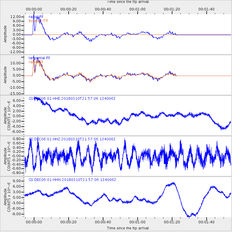
Signal To Noise
| Channel | StoN | STA | LTA |
| GS:DEC06:01:HHZ:20180310T21:57:06.134006Z | 1.2569628 | 3.8816964E-7 | 3.0881552E-7 |
| GS:DEC06:01:HHN:20180310T21:57:06.134006Z | 2.8198218 | 9.486719E-6 | 3.3642973E-6 |
| GS:DEC06:01:HHE:20180310T21:57:06.134006Z | 2.6989532 | 5.7132806E-6 | 2.1168507E-6 |
| Arrivals |
| Ps | |
| PpPs | |
| PsPs/PpSs | |


