You are here: Home > Network List > UU - University of Utah Regional Network Stations List
> Station SRU San Rafael Swell, UT, USA > Earthquake Result Viewer
SRU San Rafael Swell, UT, USA - Earthquake Result Viewer
| Earthquake location: |
Kuril Islands |
| Earthquake latitude/longitude: |
46.0/151.4 |
| Earthquake time(UTC): |
2009/04/18 (108) 19:17:58 GMT |
| Earthquake Depth: |
35 km |
| Earthquake Magnitude: |
6.3 MB, 6.3 MS, 6.6 MW, 6.4 MW |
| Earthquake Catalog/Contributor: |
WHDF/NEIC |
|
| Network: |
UU University of Utah Regional Network |
| Station: |
SRU San Rafael Swell, UT, USA |
| Lat/Lon: |
39.11 N/110.52 W |
| Elevation: |
1804 m |
|
| Distance: |
68.0 deg |
| Az: |
56.186 deg |
| Baz: |
311.907 deg |
| Ray Param: |
0.056537144 |
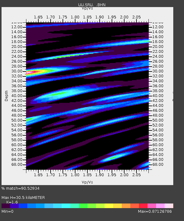
| Estimated Moho Depth: |
30.5 km |
| Estimated Crust Vp/Vs: |
1.60 |
| Assumed Crust Vp: |
6.207 km/s |
| Estimated Crust Vs: |
3.879 km/s |
| Estimated Crust Poisson's Ratio: |
0.18 |
|
| Radial Match: |
90.52934 % |
| Radial Bump: |
400 |
| Transverse Match: |
81.45023 % |
| Transverse Bump: |
400 |
| SOD ConfigId: |
2760 |
| Insert Time: |
2010-03-09 12:51:30.222 +0000 |
| GWidth: |
2.5 |
| Max Bumps: |
400 |
| Tol: |
0.001 |
|

Signal To Noise
| Channel | StoN | STA | LTA |
| UU:SRU: :BHN:20090418T19:28:23.69001Z | 12.647418 | 5.358264E-8 | 4.2366466E-9 |
| UU:SRU: :BHE:20090418T19:28:23.69001Z | 3.6881475 | 1.1676843E-8 | 3.1660454E-9 |
| UU:SRU: :BHZ:20090418T19:28:23.69001Z | 3.9938483 | 1.1509999E-8 | 2.881932E-9 |
| Arrivals |
| Ps | 3.1 SECOND |
| PpPs | 12 SECOND |
| PsPs/PpSs | 15 SECOND |


