You are here: Home > Network List > AK - Alaska Regional Network Stations List
> Station N18K Kilae Creek, AK, USA > Earthquake Result Viewer
N18K Kilae Creek, AK, USA - Earthquake Result Viewer
| Earthquake location: |
Kuril Islands |
| Earthquake latitude/longitude: |
46.4/152.4 |
| Earthquake time(UTC): |
2021/09/20 (263) 20:25:25 GMT |
| Earthquake Depth: |
25 km |
| Earthquake Magnitude: |
6.0 mww |
| Earthquake Catalog/Contributor: |
NEIC PDE/us |
|
| Network: |
AK Alaska Regional Network |
| Station: |
N18K Kilae Creek, AK, USA |
| Lat/Lon: |
60.68 N/155.89 W |
| Elevation: |
572 m |
|
| Distance: |
32.9 deg |
| Az: |
45.308 deg |
| Baz: |
268.101 deg |
| Ray Param: |
0.0784177 |
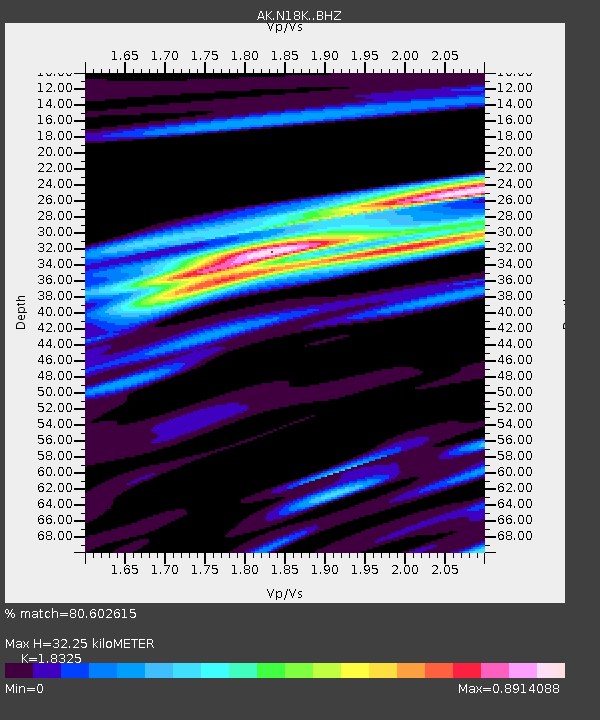
| Estimated Moho Depth: |
32.25 km |
| Estimated Crust Vp/Vs: |
1.83 |
| Assumed Crust Vp: |
6.566 km/s |
| Estimated Crust Vs: |
3.583 km/s |
| Estimated Crust Poisson's Ratio: |
0.29 |
|
| Radial Match: |
80.602615 % |
| Radial Bump: |
355 |
| Transverse Match: |
64.799446 % |
| Transverse Bump: |
400 |
| SOD ConfigId: |
25131211 |
| Insert Time: |
2021-10-04 20:28:38.774 +0000 |
| GWidth: |
2.5 |
| Max Bumps: |
400 |
| Tol: |
0.001 |
|

Signal To Noise
| Channel | StoN | STA | LTA |
| AK:N18K: :BHZ:20210920T20:31:27.239999Z | 3.1115446 | 7.28243E-7 | 2.3404549E-7 |
| AK:N18K: :BHN:20210920T20:31:27.239999Z | 1.3016678 | 3.313588E-7 | 2.5456478E-7 |
| AK:N18K: :BHE:20210920T20:31:27.239999Z | 1.6567355 | 4.7480088E-7 | 2.865882E-7 |
| Arrivals |
| Ps | 4.4 SECOND |
| PpPs | 13 SECOND |
| PsPs/PpSs | 17 SECOND |


