You are here: Home > Network List > AK - Alaska Regional Network Stations List
> Station PS08 TAPS Pump Station 8, AK, USA > Earthquake Result Viewer
PS08 TAPS Pump Station 8, AK, USA - Earthquake Result Viewer
| Earthquake location: |
Kuril Islands |
| Earthquake latitude/longitude: |
46.4/152.4 |
| Earthquake time(UTC): |
2021/09/20 (263) 20:25:25 GMT |
| Earthquake Depth: |
25 km |
| Earthquake Magnitude: |
6.0 mww |
| Earthquake Catalog/Contributor: |
NEIC PDE/us |
|
| Network: |
AK Alaska Regional Network |
| Station: |
PS08 TAPS Pump Station 8, AK, USA |
| Lat/Lon: |
64.54 N/146.82 W |
| Elevation: |
320 m |
|
| Distance: |
37.1 deg |
| Az: |
38.65 deg |
| Baz: |
270.691 deg |
| Ray Param: |
0.076272234 |
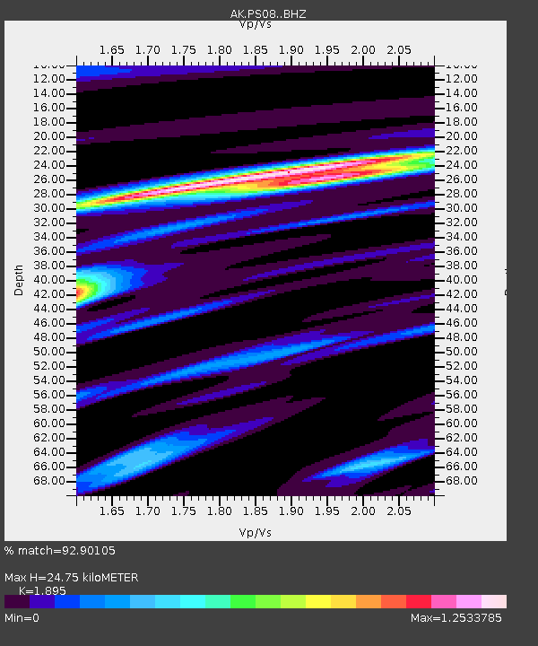
| Estimated Moho Depth: |
24.75 km |
| Estimated Crust Vp/Vs: |
1.89 |
| Assumed Crust Vp: |
6.566 km/s |
| Estimated Crust Vs: |
3.465 km/s |
| Estimated Crust Poisson's Ratio: |
0.31 |
|
| Radial Match: |
92.90105 % |
| Radial Bump: |
274 |
| Transverse Match: |
53.594566 % |
| Transverse Bump: |
400 |
| SOD ConfigId: |
25131211 |
| Insert Time: |
2021-10-04 20:28:50.632 +0000 |
| GWidth: |
2.5 |
| Max Bumps: |
400 |
| Tol: |
0.001 |
|

Signal To Noise
| Channel | StoN | STA | LTA |
| AK:PS08: :BHZ:20210920T20:32:03.668008Z | 6.301195 | 7.2228676E-7 | 1.1462696E-7 |
| AK:PS08: :BHN:20210920T20:32:03.668008Z | 2.88195 | 2.7446237E-7 | 9.523495E-8 |
| AK:PS08: :BHE:20210920T20:32:03.668008Z | 2.1062822 | 2.925523E-7 | 1.388951E-7 |
| Arrivals |
| Ps | 3.6 SECOND |
| PpPs | 10 SECOND |
| PsPs/PpSs | 14 SECOND |


