You are here: Home > Network List > AV - Alaska Volcano Observatory Stations List
> Station N25K Chitina, Valdez-Cordova, AK, USA > Earthquake Result Viewer
N25K Chitina, Valdez-Cordova, AK, USA - Earthquake Result Viewer
| Earthquake location: |
Kuril Islands |
| Earthquake latitude/longitude: |
46.4/152.4 |
| Earthquake time(UTC): |
2021/09/20 (263) 20:25:25 GMT |
| Earthquake Depth: |
25 km |
| Earthquake Magnitude: |
6.0 mww |
| Earthquake Catalog/Contributor: |
NEIC PDE/us |
|
| Network: |
AV Alaska Volcano Observatory |
| Station: |
N25K Chitina, Valdez-Cordova, AK, USA |
| Lat/Lon: |
61.61 N/144.60 W |
| Elevation: |
1087 m |
|
| Distance: |
38.3 deg |
| Az: |
43.353 deg |
| Baz: |
276.392 deg |
| Ray Param: |
0.075603485 |
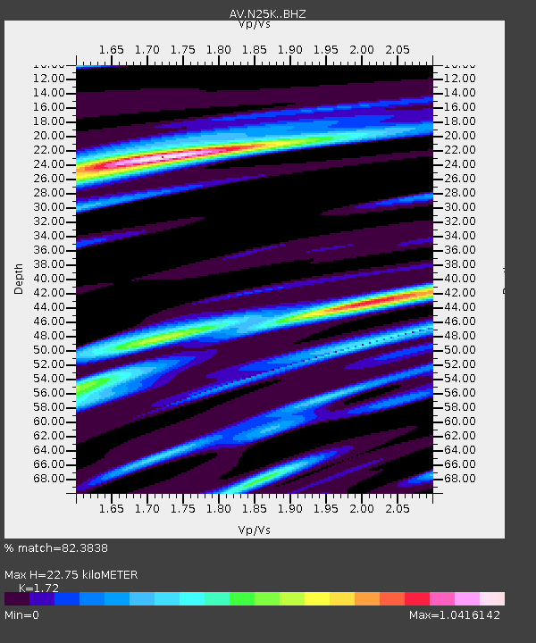
| Estimated Moho Depth: |
22.75 km |
| Estimated Crust Vp/Vs: |
1.72 |
| Assumed Crust Vp: |
6.566 km/s |
| Estimated Crust Vs: |
3.818 km/s |
| Estimated Crust Poisson's Ratio: |
0.24 |
|
| Radial Match: |
82.3838 % |
| Radial Bump: |
400 |
| Transverse Match: |
66.70565 % |
| Transverse Bump: |
400 |
| SOD ConfigId: |
25131211 |
| Insert Time: |
2021-10-04 20:30:36.555 +0000 |
| GWidth: |
2.5 |
| Max Bumps: |
400 |
| Tol: |
0.001 |
|

Signal To Noise
| Channel | StoN | STA | LTA |
| AV:N25K: :BHZ:20210920T20:32:13.750009Z | 2.4180229 | 4.787699E-7 | 1.9800058E-7 |
| AV:N25K: :BHN:20210920T20:32:13.750009Z | 1.5042722 | 2.164969E-7 | 1.4392135E-7 |
| AV:N25K: :BHE:20210920T20:32:13.750009Z | 1.8657693 | 3.096162E-7 | 1.6594561E-7 |
| Arrivals |
| Ps | 2.7 SECOND |
| PpPs | 8.7 SECOND |
| PsPs/PpSs | 11 SECOND |


