You are here: Home > Network List > UU - University of Utah Regional Network Stations List
> Station SRU San Rafael Swell, UT, USA > Earthquake Result Viewer
SRU San Rafael Swell, UT, USA - Earthquake Result Viewer
| Earthquake location: |
Kuril Islands |
| Earthquake latitude/longitude: |
51.0/157.6 |
| Earthquake time(UTC): |
2008/07/24 (206) 01:43:16 GMT |
| Earthquake Depth: |
27 km |
| Earthquake Magnitude: |
6.0 MB, 6.0 MS, 6.2 MW, 6.2 MW |
| Earthquake Catalog/Contributor: |
WHDF/NEIC |
|
| Network: |
UU University of Utah Regional Network |
| Station: |
SRU San Rafael Swell, UT, USA |
| Lat/Lon: |
39.11 N/110.52 W |
| Elevation: |
1804 m |
|
| Distance: |
61.9 deg |
| Az: |
61.786 deg |
| Baz: |
314.259 deg |
| Ray Param: |
0.060519323 |
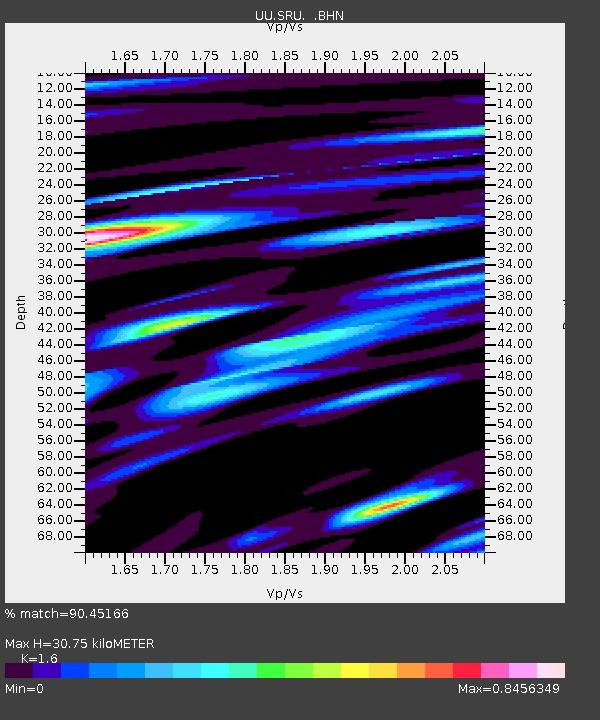
| Estimated Moho Depth: |
30.75 km |
| Estimated Crust Vp/Vs: |
1.60 |
| Assumed Crust Vp: |
6.207 km/s |
| Estimated Crust Vs: |
3.879 km/s |
| Estimated Crust Poisson's Ratio: |
0.18 |
|
| Radial Match: |
90.45166 % |
| Radial Bump: |
400 |
| Transverse Match: |
84.532295 % |
| Transverse Bump: |
400 |
| SOD ConfigId: |
2504 |
| Insert Time: |
2010-03-09 12:51:58.389 +0000 |
| GWidth: |
2.5 |
| Max Bumps: |
400 |
| Tol: |
0.001 |
|

Signal To Noise
| Channel | StoN | STA | LTA |
| UU:SRU: :BHN:20080724T01:53:02.465012Z | 17.877987 | 3.758335E-8 | 2.1022137E-9 |
| UU:SRU: :BHE:20080724T01:53:02.465012Z | 8.626841 | 1.1975318E-8 | 1.3881464E-9 |
| UU:SRU: :BHZ:20080724T01:53:02.465012Z | 5.1747775 | 1.0701637E-8 | 2.0680382E-9 |
| Arrivals |
| Ps | 3.1 SECOND |
| PpPs | 12 SECOND |
| PsPs/PpSs | 15 SECOND |


