You are here: Home > Network List > CI - Caltech Regional Seismic Network Stations List
> Station DAN Danby, California, USA > Earthquake Result Viewer
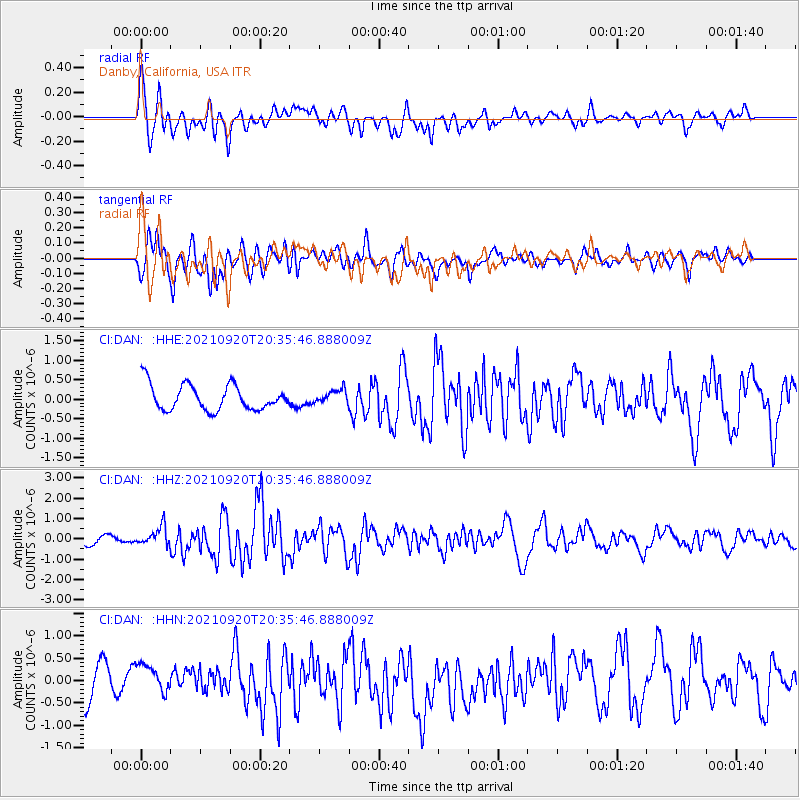
DAN Danby, California, USA - Earthquake Result Viewer
*The percent match for this event was below the threshold and hence no stack was calculated.
| Earthquake location: |
Kuril Islands |
| Earthquake latitude/longitude: |
46.4/152.4 |
| Earthquake time(UTC): |
2021/09/20 (263) 20:25:25 GMT |
| Earthquake Depth: |
25 km |
| Earthquake Magnitude: |
6.0 mww |
| Earthquake Catalog/Contributor: |
NEIC PDE/us |
|
| Network: |
CI Caltech Regional Seismic Network |
| Station: |
DAN Danby, California, USA |
| Lat/Lon: |
34.64 N/115.38 W |
| Elevation: |
398 m |
|
| Distance: |
67.3 deg |
| Az: |
63.297 deg |
| Baz: |
311.435 deg |
| Ray Param: |
$rayparam |
*The percent match for this event was below the threshold and hence was not used in the summary stack. |
|
| Radial Match: |
75.34777 % |
| Radial Bump: |
400 |
| Transverse Match: |
73.80316 % |
| Transverse Bump: |
400 |
| SOD ConfigId: |
25131211 |
| Insert Time: |
2021-10-04 20:33:14.252 +0000 |
| GWidth: |
2.5 |
| Max Bumps: |
400 |
| Tol: |
0.001 |
|
Signal To Noise
| Channel | StoN | STA | LTA |
| CI:DAN: :HHZ:20210920T20:35:46.888009Z | 1.7073474 | 4.5923855E-7 | 2.689778E-7 |
| CI:DAN: :HHN:20210920T20:35:46.888009Z | 1.0063189 | 3.0826928E-7 | 3.063336E-7 |
| CI:DAN: :HHE:20210920T20:35:46.888009Z | 0.538506 | 1.755183E-7 | 3.2593564E-7 |
| Arrivals |
| Ps | |
| PpPs | |
| PsPs/PpSs | |


