You are here: Home > Network List > CI - Caltech Regional Seismic Network Stations List
> Station DGR Domenigoni Reservoir, California, USA > Earthquake Result Viewer
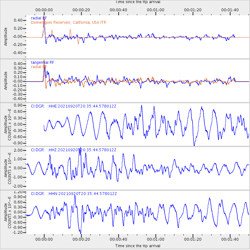
DGR Domenigoni Reservoir, California, USA - Earthquake Result Viewer
*The percent match for this event was below the threshold and hence no stack was calculated.
| Earthquake location: |
Kuril Islands |
| Earthquake latitude/longitude: |
46.4/152.4 |
| Earthquake time(UTC): |
2021/09/20 (263) 20:25:25 GMT |
| Earthquake Depth: |
25 km |
| Earthquake Magnitude: |
6.0 mww |
| Earthquake Catalog/Contributor: |
NEIC PDE/us |
|
| Network: |
CI Caltech Regional Seismic Network |
| Station: |
DGR Domenigoni Reservoir, California, USA |
| Lat/Lon: |
33.65 N/117.01 W |
| Elevation: |
609 m |
|
| Distance: |
66.9 deg |
| Az: |
65.068 deg |
| Baz: |
311.215 deg |
| Ray Param: |
$rayparam |
*The percent match for this event was below the threshold and hence was not used in the summary stack. |
|
| Radial Match: |
69.77491 % |
| Radial Bump: |
367 |
| Transverse Match: |
66.05431 % |
| Transverse Bump: |
400 |
| SOD ConfigId: |
25131211 |
| Insert Time: |
2021-10-04 20:33:15.901 +0000 |
| GWidth: |
2.5 |
| Max Bumps: |
400 |
| Tol: |
0.001 |
|
Signal To Noise
| Channel | StoN | STA | LTA |
| CI:DGR: :HHZ:20210920T20:35:44.578012Z | 2.3792667 | 6.3324427E-7 | 2.6615103E-7 |
| CI:DGR: :HHN:20210920T20:35:44.578012Z | 0.70918 | 1.7723951E-7 | 2.4992175E-7 |
| CI:DGR: :HHE:20210920T20:35:44.578012Z | 1.5698026 | 4.2326053E-7 | 2.6962658E-7 |
| Arrivals |
| Ps | |
| PpPs | |
| PsPs/PpSs | |


