You are here: Home > Network List > UU - University of Utah Regional Network Stations List
> Station SRU San Rafael Swell, UT, USA > Earthquake Result Viewer
SRU San Rafael Swell, UT, USA - Earthquake Result Viewer
| Earthquake location: |
Kermadec Islands Region |
| Earthquake latitude/longitude: |
-27.4/-176.3 |
| Earthquake time(UTC): |
2009/02/18 (049) 21:53:45 GMT |
| Earthquake Depth: |
25 km |
| Earthquake Magnitude: |
6.8 MB, 7.2 MS, 6.9 MW, 6.9 MW |
| Earthquake Catalog/Contributor: |
WHDF/NEIC |
|
| Network: |
UU University of Utah Regional Network |
| Station: |
SRU San Rafael Swell, UT, USA |
| Lat/Lon: |
39.11 N/110.52 W |
| Elevation: |
1804 m |
|
| Distance: |
90.3 deg |
| Az: |
45.208 deg |
| Baz: |
234.176 deg |
| Ray Param: |
0.04168403 |
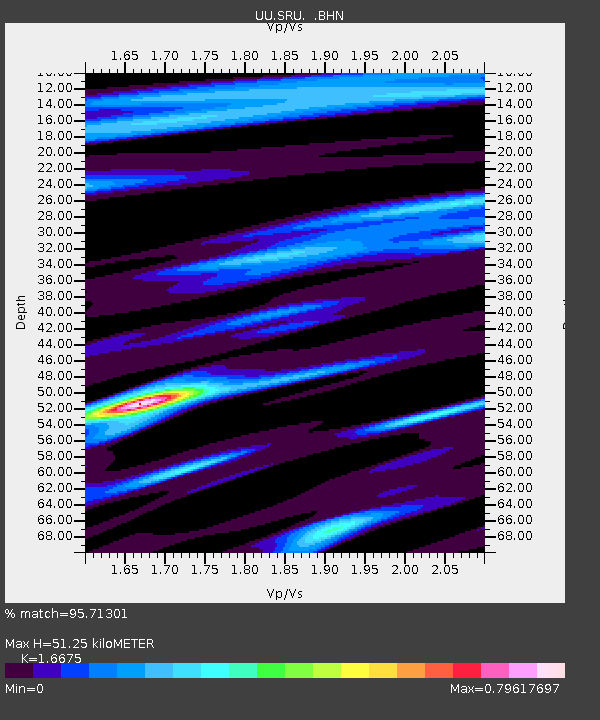
| Estimated Moho Depth: |
51.25 km |
| Estimated Crust Vp/Vs: |
1.67 |
| Assumed Crust Vp: |
6.207 km/s |
| Estimated Crust Vs: |
3.722 km/s |
| Estimated Crust Poisson's Ratio: |
0.22 |
|
| Radial Match: |
95.71301 % |
| Radial Bump: |
296 |
| Transverse Match: |
88.9223 % |
| Transverse Bump: |
400 |
| SOD ConfigId: |
2658 |
| Insert Time: |
2010-03-09 12:52:21.923 +0000 |
| GWidth: |
2.5 |
| Max Bumps: |
400 |
| Tol: |
0.001 |
|

Signal To Noise
| Channel | StoN | STA | LTA |
| UU:SRU: :BHN:20090218T22:06:12.115017Z | 7.5268307 | 5.416205E-8 | 7.1958643E-9 |
| UU:SRU: :BHE:20090218T22:06:12.115017Z | 1.811464 | 9.0917585E-9 | 5.0190114E-9 |
| UU:SRU: :BHZ:20090218T22:06:12.115017Z | 2.0648808 | 1.5061772E-8 | 7.2942568E-9 |
| Arrivals |
| Ps | 5.6 SECOND |
| PpPs | 22 SECOND |
| PsPs/PpSs | 27 SECOND |


