You are here: Home > Network List > MM - Myanmar National Seismic Network Stations List
> Station TGI Taung Gyi, Myanmar > Earthquake Result Viewer
TGI Taung Gyi, Myanmar - Earthquake Result Viewer
| Earthquake location: |
Kuril Islands |
| Earthquake latitude/longitude: |
46.4/152.4 |
| Earthquake time(UTC): |
2021/09/20 (263) 20:25:25 GMT |
| Earthquake Depth: |
25 km |
| Earthquake Magnitude: |
6.0 mww |
| Earthquake Catalog/Contributor: |
NEIC PDE/us |
|
| Network: |
MM Myanmar National Seismic Network |
| Station: |
TGI Taung Gyi, Myanmar |
| Lat/Lon: |
20.77 N/97.03 E |
| Elevation: |
1458 m |
|
| Distance: |
51.5 deg |
| Az: |
259.702 deg |
| Baz: |
46.679 deg |
| Ray Param: |
0.06733389 |
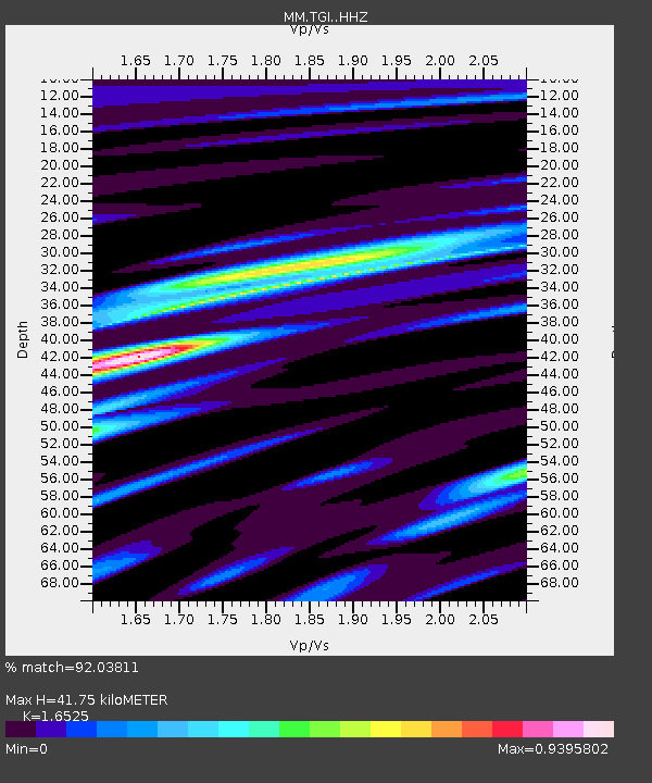
| Estimated Moho Depth: |
41.75 km |
| Estimated Crust Vp/Vs: |
1.65 |
| Assumed Crust Vp: |
6.316 km/s |
| Estimated Crust Vs: |
3.822 km/s |
| Estimated Crust Poisson's Ratio: |
0.21 |
|
| Radial Match: |
92.03811 % |
| Radial Bump: |
298 |
| Transverse Match: |
82.252945 % |
| Transverse Bump: |
400 |
| SOD ConfigId: |
25131211 |
| Insert Time: |
2021-10-04 20:40:16.614 +0000 |
| GWidth: |
2.5 |
| Max Bumps: |
400 |
| Tol: |
0.001 |
|

Signal To Noise
| Channel | StoN | STA | LTA |
| MM:TGI: :HHZ:20210920T20:33:58.279977Z | 10.66945 | 5.8671463E-7 | 5.499015E-8 |
| MM:TGI: :HHN:20210920T20:33:58.279977Z | 3.753085 | 2.1866818E-7 | 5.8263584E-8 |
| MM:TGI: :HHE:20210920T20:33:58.279977Z | 3.8369653 | 2.0437477E-7 | 5.3264692E-8 |
| Arrivals |
| Ps | 4.6 SECOND |
| PpPs | 17 SECOND |
| PsPs/PpSs | 21 SECOND |


