You are here: Home > Network List > WY - Yellowstone Wyoming Seismic Network Stations List
> Station YHH Holmes Hill, YNP, WY, USA > Earthquake Result Viewer
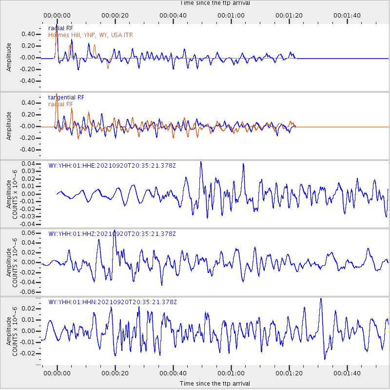
YHH Holmes Hill, YNP, WY, USA - Earthquake Result Viewer
*The percent match for this event was below the threshold and hence no stack was calculated.
| Earthquake location: |
Kuril Islands |
| Earthquake latitude/longitude: |
46.4/152.4 |
| Earthquake time(UTC): |
2021/09/20 (263) 20:25:25 GMT |
| Earthquake Depth: |
25 km |
| Earthquake Magnitude: |
6.0 mww |
| Earthquake Catalog/Contributor: |
NEIC PDE/us |
|
| Network: |
WY Yellowstone Wyoming Seismic Network |
| Station: |
YHH Holmes Hill, YNP, WY, USA |
| Lat/Lon: |
44.79 N/110.85 W |
| Elevation: |
2717 m |
|
| Distance: |
63.3 deg |
| Az: |
52.32 deg |
| Baz: |
309.728 deg |
| Ray Param: |
$rayparam |
*The percent match for this event was below the threshold and hence was not used in the summary stack. |
|
| Radial Match: |
75.046844 % |
| Radial Bump: |
400 |
| Transverse Match: |
73.15971 % |
| Transverse Bump: |
400 |
| SOD ConfigId: |
25131211 |
| Insert Time: |
2021-10-04 20:51:53.477 +0000 |
| GWidth: |
2.5 |
| Max Bumps: |
400 |
| Tol: |
0.001 |
|
Signal To Noise
| Channel | StoN | STA | LTA |
| WY:YHH:01:HHZ:20210920T20:35:21.378Z | 3.4910443 | 9.258536E-9 | 2.652082E-9 |
| WY:YHH:01:HHN:20210920T20:35:21.378Z | 1.0015202 | 4.34051E-9 | 4.3339217E-9 |
| WY:YHH:01:HHE:20210920T20:35:21.378Z | 1.1698523 | 5.961962E-9 | 5.0963376E-9 |
| Arrivals |
| Ps | |
| PpPs | |
| PsPs/PpSs | |


