You are here: Home > Network List > G - GEOSCOPE Stations List
> Station MPG Montagne des Peres, French Guyana > Earthquake Result Viewer
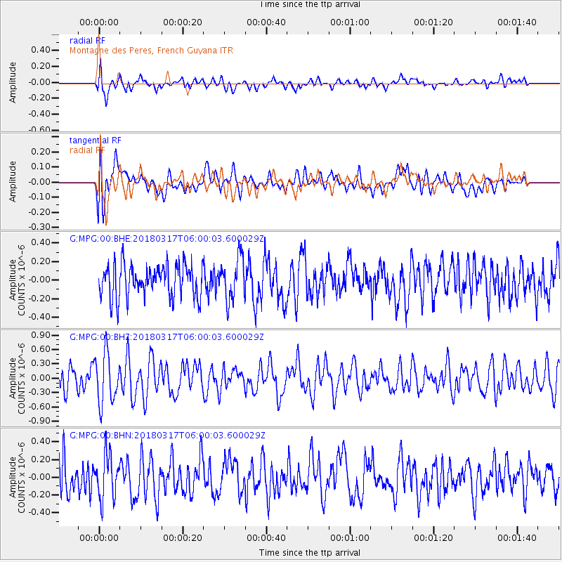
MPG Montagne des Peres, French Guyana - Earthquake Result Viewer
*The percent match for this event was below the threshold and hence no stack was calculated.
| Earthquake location: |
Southern Mid-Atlantic Ridge |
| Earthquake latitude/longitude: |
-47.7/-13.5 |
| Earthquake time(UTC): |
2018/03/17 (076) 05:50:09 GMT |
| Earthquake Depth: |
10 km |
| Earthquake Magnitude: |
5.5 mb |
| Earthquake Catalog/Contributor: |
NEIC PDE/us |
|
| Network: |
G GEOSCOPE |
| Station: |
MPG Montagne des Peres, French Guyana |
| Lat/Lon: |
5.11 N/52.64 W |
| Elevation: |
147 m |
|
| Distance: |
62.8 deg |
| Az: |
315.016 deg |
| Baz: |
151.334 deg |
| Ray Param: |
$rayparam |
*The percent match for this event was below the threshold and hence was not used in the summary stack. |
|
| Radial Match: |
60.170074 % |
| Radial Bump: |
400 |
| Transverse Match: |
52.943047 % |
| Transverse Bump: |
400 |
| SOD ConfigId: |
2615551 |
| Insert Time: |
2018-03-31 05:51:26.384 +0000 |
| GWidth: |
2.5 |
| Max Bumps: |
400 |
| Tol: |
0.001 |
|
Signal To Noise
| Channel | StoN | STA | LTA |
| G:MPG:00:BHZ:20180317T06:00:03.600029Z | 2.1670117 | 5.253272E-7 | 2.424201E-7 |
| G:MPG:00:BHN:20180317T06:00:03.600029Z | 1.2494472 | 2.5121113E-7 | 2.0105782E-7 |
| G:MPG:00:BHE:20180317T06:00:03.600029Z | 1.3203706 | 2.2649341E-7 | 1.7153776E-7 |
| Arrivals |
| Ps | |
| PpPs | |
| PsPs/PpSs | |


