You are here: Home > Network List > IU - Global Seismograph Network (GSN - IRIS/USGS) Stations List
> Station CTAO Charters Towers, Australia > Earthquake Result Viewer
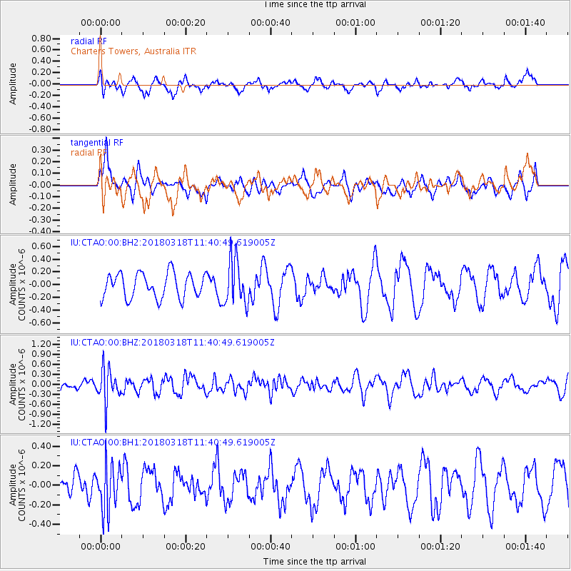
CTAO Charters Towers, Australia - Earthquake Result Viewer
*The percent match for this event was below the threshold and hence no stack was calculated.
| Earthquake location: |
Minahassa Peninsula, Sulawesi |
| Earthquake latitude/longitude: |
0.5/121.5 |
| Earthquake time(UTC): |
2018/03/18 (077) 11:35:05 GMT |
| Earthquake Depth: |
107 km |
| Earthquake Magnitude: |
5.3 Mww |
| Earthquake Catalog/Contributor: |
NEIC PDE/us |
|
| Network: |
IU Global Seismograph Network (GSN - IRIS/USGS) |
| Station: |
CTAO Charters Towers, Australia |
| Lat/Lon: |
20.09 S/146.25 E |
| Elevation: |
357 m |
|
| Distance: |
31.8 deg |
| Az: |
131.516 deg |
| Baz: |
307.192 deg |
| Ray Param: |
$rayparam |
*The percent match for this event was below the threshold and hence was not used in the summary stack. |
|
| Radial Match: |
58.436275 % |
| Radial Bump: |
368 |
| Transverse Match: |
52.56349 % |
| Transverse Bump: |
400 |
| SOD ConfigId: |
2615551 |
| Insert Time: |
2018-04-01 11:40:35.044 +0000 |
| GWidth: |
2.5 |
| Max Bumps: |
400 |
| Tol: |
0.001 |
|
Signal To Noise
| Channel | StoN | STA | LTA |
| IU:CTAO:00:BHZ:20180318T11:40:49.619005Z | 3.2307868 | 4.9354776E-7 | 1.5276395E-7 |
| IU:CTAO:00:BH1:20180318T11:40:49.619005Z | 1.3052537 | 2.3641152E-7 | 1.8112304E-7 |
| IU:CTAO:00:BH2:20180318T11:40:49.619005Z | 1.8643324 | 3.62034E-7 | 1.9418962E-7 |
| Arrivals |
| Ps | |
| PpPs | |
| PsPs/PpSs | |


