You are here: Home > Network List > AV - Alaska Volcano Observatory Stations List
> Station SPWE Spurr West, Mount Spurr, Alaska > Earthquake Result Viewer
SPWE Spurr West, Mount Spurr, Alaska - Earthquake Result Viewer
| Earthquake location: |
Near Coast Of Nicaragua |
| Earthquake latitude/longitude: |
12.1/-87.8 |
| Earthquake time(UTC): |
2021/09/22 (265) 09:57:07 GMT |
| Earthquake Depth: |
10 km |
| Earthquake Magnitude: |
6.7 Mi |
| Earthquake Catalog/Contributor: |
NEIC PDE/at |
|
| Network: |
AV Alaska Volcano Observatory |
| Station: |
SPWE Spurr West, Mount Spurr, Alaska |
| Lat/Lon: |
61.27 N/152.56 W |
| Elevation: |
1317 m |
|
| Distance: |
67.4 deg |
| Az: |
331.755 deg |
| Baz: |
106.648 deg |
| Ray Param: |
0.056975875 |
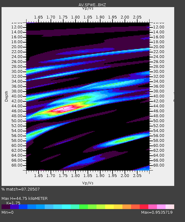
| Estimated Moho Depth: |
44.75 km |
| Estimated Crust Vp/Vs: |
1.75 |
| Assumed Crust Vp: |
6.566 km/s |
| Estimated Crust Vs: |
3.752 km/s |
| Estimated Crust Poisson's Ratio: |
0.26 |
|
| Radial Match: |
87.28507 % |
| Radial Bump: |
370 |
| Transverse Match: |
68.17327 % |
| Transverse Bump: |
400 |
| SOD ConfigId: |
25131211 |
| Insert Time: |
2021-10-06 10:05:12.847 +0000 |
| GWidth: |
2.5 |
| Max Bumps: |
400 |
| Tol: |
0.001 |
|

Signal To Noise
| Channel | StoN | STA | LTA |
| AV:SPWE: :BHZ:20210922T10:07:31.440002Z | 5.67346 | 9.259864E-7 | 1.6321371E-7 |
| AV:SPWE: :BHN:20210922T10:07:31.440002Z | 1.9895843 | 2.8865796E-7 | 1.4508456E-7 |
| AV:SPWE: :BHE:20210922T10:07:31.440002Z | 3.11144 | 3.2441662E-7 | 1.0426575E-7 |
| Arrivals |
| Ps | 5.3 SECOND |
| PpPs | 18 SECOND |
| PsPs/PpSs | 23 SECOND |


