You are here: Home > Network List > BC - Red Sismica del Noroeste de Mexico Stations List
> Station PIX Pinacate, , SON, MEXICO > Earthquake Result Viewer
PIX Pinacate, , SON, MEXICO - Earthquake Result Viewer
| Earthquake location: |
Near Coast Of Nicaragua |
| Earthquake latitude/longitude: |
12.1/-87.8 |
| Earthquake time(UTC): |
2021/09/22 (265) 09:57:07 GMT |
| Earthquake Depth: |
10 km |
| Earthquake Magnitude: |
6.7 Mi |
| Earthquake Catalog/Contributor: |
NEIC PDE/at |
|
| Network: |
BC Red Sismica del Noroeste de Mexico |
| Station: |
PIX Pinacate, , SON, MEXICO |
| Lat/Lon: |
31.56 N/113.46 W |
| Elevation: |
78 m |
|
| Distance: |
30.6 deg |
| Az: |
313.371 deg |
| Baz: |
123.603 deg |
| Ray Param: |
0.07938267 |
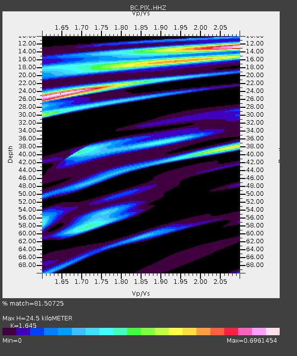
| Estimated Moho Depth: |
24.5 km |
| Estimated Crust Vp/Vs: |
1.64 |
| Assumed Crust Vp: |
6.276 km/s |
| Estimated Crust Vs: |
3.815 km/s |
| Estimated Crust Poisson's Ratio: |
0.21 |
|
| Radial Match: |
81.50725 % |
| Radial Bump: |
368 |
| Transverse Match: |
74.71048 % |
| Transverse Bump: |
400 |
| SOD ConfigId: |
25131211 |
| Insert Time: |
2021-10-06 10:06:11.940 +0000 |
| GWidth: |
2.5 |
| Max Bumps: |
400 |
| Tol: |
0.001 |
|

Signal To Noise
| Channel | StoN | STA | LTA |
| BC:PIX: :HHZ:20210922T10:02:50.024994Z | 7.5803394 | 1.2842818E-6 | 1.6942272E-7 |
| BC:PIX: :HHN:20210922T10:02:50.024994Z | 2.8876538 | 4.990115E-7 | 1.7280863E-7 |
| BC:PIX: :HHE:20210922T10:02:50.024994Z | 1.9475803 | 6.2802985E-7 | 3.2246672E-7 |
| Arrivals |
| Ps | 2.7 SECOND |
| PpPs | 9.5 SECOND |
| PsPs/PpSs | 12 SECOND |


