You are here: Home > Network List > IW - Intermountain West Stations List
> Station PLID Pearl Lake, Idaho, USA > Earthquake Result Viewer
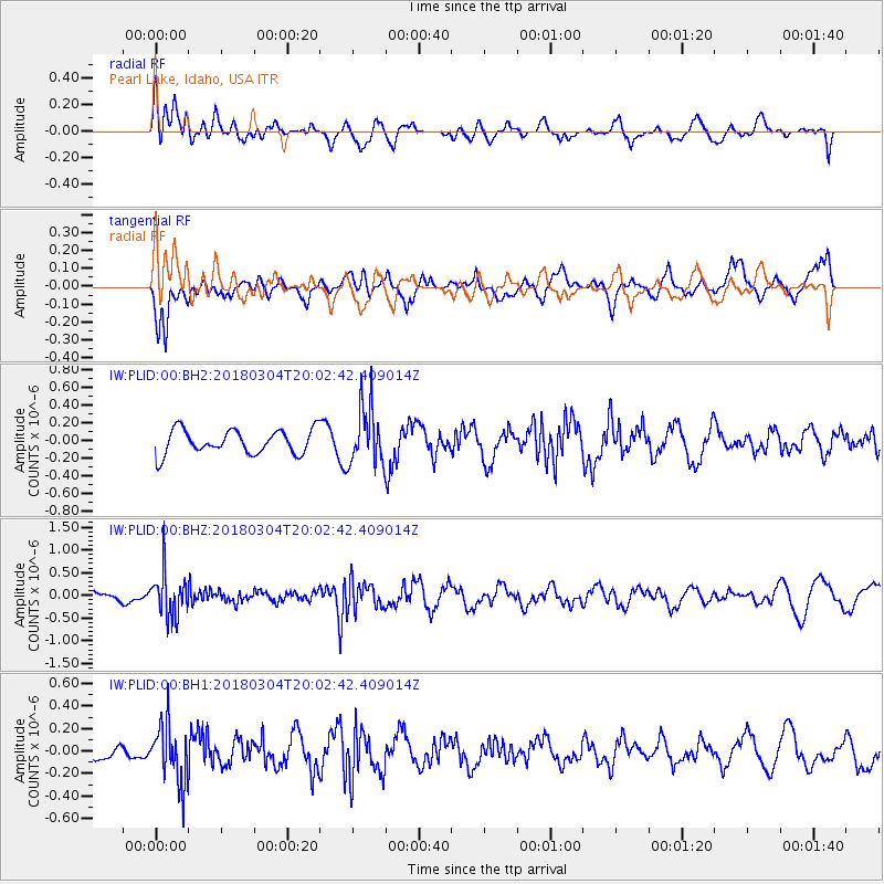
PLID Pearl Lake, Idaho, USA - Earthquake Result Viewer
*The percent match for this event was below the threshold and hence no stack was calculated.
| Earthquake location: |
Kuril Islands |
| Earthquake latitude/longitude: |
45.1/147.8 |
| Earthquake time(UTC): |
2018/03/04 (063) 19:52:52 GMT |
| Earthquake Depth: |
104 km |
| Earthquake Magnitude: |
5.4 Mww |
| Earthquake Catalog/Contributor: |
NEIC PDE/us |
|
| Network: |
IW Intermountain West |
| Station: |
PLID Pearl Lake, Idaho, USA |
| Lat/Lon: |
45.09 N/116.00 W |
| Elevation: |
2164 m |
|
| Distance: |
63.7 deg |
| Az: |
51.794 deg |
| Baz: |
308.166 deg |
| Ray Param: |
$rayparam |
*The percent match for this event was below the threshold and hence was not used in the summary stack. |
|
| Radial Match: |
51.66548 % |
| Radial Bump: |
400 |
| Transverse Match: |
71.768684 % |
| Transverse Bump: |
400 |
| SOD ConfigId: |
2615551 |
| Insert Time: |
2018-04-02 13:34:04.420 +0000 |
| GWidth: |
2.5 |
| Max Bumps: |
400 |
| Tol: |
0.001 |
|
Signal To Noise
| Channel | StoN | STA | LTA |
| IW:PLID:00:BHZ:20180304T20:02:42.409014Z | 2.3783832 | 4.774836E-7 | 2.0075973E-7 |
| IW:PLID:00:BH1:20180304T20:02:42.409014Z | 1.6128209 | 2.522361E-7 | 1.5639436E-7 |
| IW:PLID:00:BH2:20180304T20:02:42.409014Z | 2.4015815 | 3.2805414E-7 | 1.365992E-7 |
| Arrivals |
| Ps | |
| PpPs | |
| PsPs/PpSs | |


