You are here: Home > Network List > C1 - Red Sismologica Nacional Stations List
> Station ML02 Panimavida > Earthquake Result Viewer
ML02 Panimavida - Earthquake Result Viewer
| Earthquake location: |
Near Coast Of Nicaragua |
| Earthquake latitude/longitude: |
12.1/-87.8 |
| Earthquake time(UTC): |
2021/09/22 (265) 09:57:07 GMT |
| Earthquake Depth: |
10 km |
| Earthquake Magnitude: |
6.7 Mi |
| Earthquake Catalog/Contributor: |
NEIC PDE/at |
|
| Network: |
C1 Red Sismologica Nacional |
| Station: |
ML02 Panimavida |
| Lat/Lon: |
35.76 S/71.42 W |
| Elevation: |
237 m |
|
| Distance: |
50.1 deg |
| Az: |
162.592 deg |
| Baz: |
338.913 deg |
| Ray Param: |
0.0683096 |
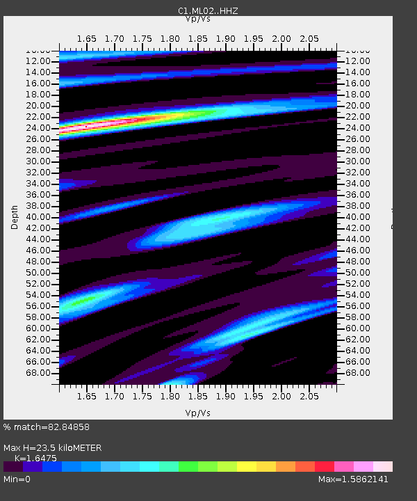
| Estimated Moho Depth: |
23.5 km |
| Estimated Crust Vp/Vs: |
1.65 |
| Assumed Crust Vp: |
6.481 km/s |
| Estimated Crust Vs: |
3.934 km/s |
| Estimated Crust Poisson's Ratio: |
0.21 |
|
| Radial Match: |
82.84858 % |
| Radial Bump: |
400 |
| Transverse Match: |
77.76033 % |
| Transverse Bump: |
400 |
| SOD ConfigId: |
25131211 |
| Insert Time: |
2021-10-06 10:08:05.326 +0000 |
| GWidth: |
2.5 |
| Max Bumps: |
400 |
| Tol: |
0.001 |
|

Signal To Noise
| Channel | StoN | STA | LTA |
| C1:ML02: :HHZ:20210922T10:05:30.829987Z | 8.761836 | 2.6698212E-6 | 3.0471026E-7 |
| C1:ML02: :HHN:20210922T10:05:30.829987Z | 2.845277 | 1.0671075E-6 | 3.7504523E-7 |
| C1:ML02: :HHE:20210922T10:05:30.829987Z | 1.2770044 | 5.6406316E-7 | 4.417081E-7 |
| Arrivals |
| Ps | 2.5 SECOND |
| PpPs | 9.0 SECOND |
| PsPs/PpSs | 12 SECOND |


