You are here: Home > Network List > C1 - Red Sismologica Nacional Stations List
> Station MT10 Hacienda Santa Martina > Earthquake Result Viewer
MT10 Hacienda Santa Martina - Earthquake Result Viewer
| Earthquake location: |
Near Coast Of Nicaragua |
| Earthquake latitude/longitude: |
12.1/-87.8 |
| Earthquake time(UTC): |
2021/09/22 (265) 09:57:07 GMT |
| Earthquake Depth: |
10 km |
| Earthquake Magnitude: |
6.7 Mi |
| Earthquake Catalog/Contributor: |
NEIC PDE/at |
|
| Network: |
C1 Red Sismologica Nacional |
| Station: |
MT10 Hacienda Santa Martina |
| Lat/Lon: |
33.27 S/70.54 W |
| Elevation: |
1410 m |
|
| Distance: |
48.0 deg |
| Az: |
160.465 deg |
| Baz: |
337.022 deg |
| Ray Param: |
0.06963252 |
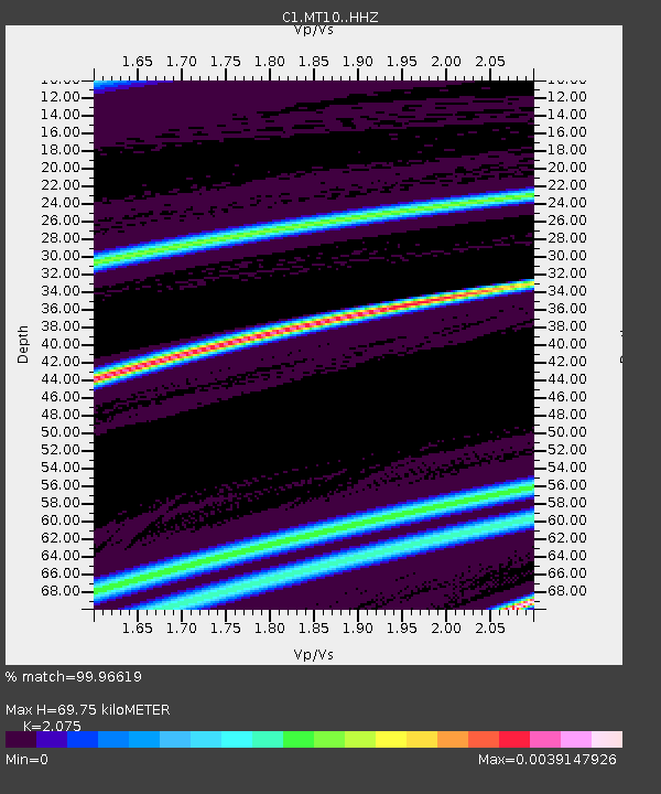
| Estimated Moho Depth: |
69.75 km |
| Estimated Crust Vp/Vs: |
2.08 |
| Assumed Crust Vp: |
6.481 km/s |
| Estimated Crust Vs: |
3.123 km/s |
| Estimated Crust Poisson's Ratio: |
0.35 |
|
| Radial Match: |
99.96619 % |
| Radial Bump: |
7 |
| Transverse Match: |
99.86178 % |
| Transverse Bump: |
26 |
| SOD ConfigId: |
25131211 |
| Insert Time: |
2021-10-06 10:08:13.344 +0000 |
| GWidth: |
2.5 |
| Max Bumps: |
400 |
| Tol: |
0.001 |
|

Signal To Noise
| Channel | StoN | STA | LTA |
| C1:MT10: :HHZ:20210922T10:05:15.298004Z | 5.639231 | 9.493253E-7 | 1.6834302E-7 |
| C1:MT10: :HHN:20210922T10:05:15.298004Z | 5.7202125 | 1.2762713E-6 | 2.2311606E-7 |
| C1:MT10: :HHE:20210922T10:05:15.298004Z | 1.195421 | 1.9609224E-8 | 1.6403614E-8 |
| Arrivals |
| Ps | 12 SECOND |
| PpPs | 31 SECOND |
| PsPs/PpSs | 44 SECOND |


