You are here: Home > Network List > CC - Cascade Chain Volcano Monitoring Stations List
> Station TIMB Timberline, OR > Earthquake Result Viewer
TIMB Timberline, OR - Earthquake Result Viewer
| Earthquake location: |
Near Coast Of Nicaragua |
| Earthquake latitude/longitude: |
12.1/-87.8 |
| Earthquake time(UTC): |
2021/09/22 (265) 09:57:07 GMT |
| Earthquake Depth: |
10 km |
| Earthquake Magnitude: |
6.7 Mi |
| Earthquake Catalog/Contributor: |
NEIC PDE/at |
|
| Network: |
CC Cascade Chain Volcano Monitoring |
| Station: |
TIMB Timberline, OR |
| Lat/Lon: |
45.34 N/121.71 W |
| Elevation: |
1869 m |
|
| Distance: |
43.9 deg |
| Az: |
325.447 deg |
| Baz: |
128.142 deg |
| Ray Param: |
0.07223181 |
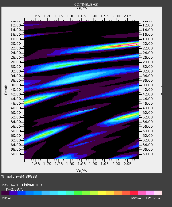
| Estimated Moho Depth: |
20.0 km |
| Estimated Crust Vp/Vs: |
2.09 |
| Assumed Crust Vp: |
6.597 km/s |
| Estimated Crust Vs: |
3.16 km/s |
| Estimated Crust Poisson's Ratio: |
0.35 |
|
| Radial Match: |
84.39838 % |
| Radial Bump: |
400 |
| Transverse Match: |
84.8868 % |
| Transverse Bump: |
400 |
| SOD ConfigId: |
25131211 |
| Insert Time: |
2021-10-06 10:10:05.608 +0000 |
| GWidth: |
2.5 |
| Max Bumps: |
400 |
| Tol: |
0.001 |
|

Signal To Noise
| Channel | StoN | STA | LTA |
| CC:TIMB: :BHZ:20210922T10:04:43.040009Z | 25.053755 | 4.5402758E-6 | 1.8122137E-7 |
| CC:TIMB: :BHN:20210922T10:04:43.040009Z | 11.534453 | 3.4551383E-6 | 2.9954938E-7 |
| CC:TIMB: :BHE:20210922T10:04:43.040009Z | 12.604169 | 3.8371672E-6 | 3.0443638E-7 |
| Arrivals |
| Ps | 3.5 SECOND |
| PpPs | 8.8 SECOND |
| PsPs/PpSs | 12 SECOND |


