You are here: Home > Network List > N4 - Central and EAstern US Network Stations List
> Station I62A Tamworth, NH, USA > Earthquake Result Viewer
I62A Tamworth, NH, USA - Earthquake Result Viewer
| Earthquake location: |
Near Coast Of Nicaragua |
| Earthquake latitude/longitude: |
12.1/-87.8 |
| Earthquake time(UTC): |
2021/09/22 (265) 09:57:07 GMT |
| Earthquake Depth: |
10 km |
| Earthquake Magnitude: |
6.7 Mi |
| Earthquake Catalog/Contributor: |
NEIC PDE/at |
|
| Network: |
N4 Central and EAstern US Network |
| Station: |
I62A Tamworth, NH, USA |
| Lat/Lon: |
43.87 N/71.34 W |
| Elevation: |
264 m |
|
| Distance: |
34.7 deg |
| Az: |
21.104 deg |
| Baz: |
209.141 deg |
| Ray Param: |
0.07761582 |
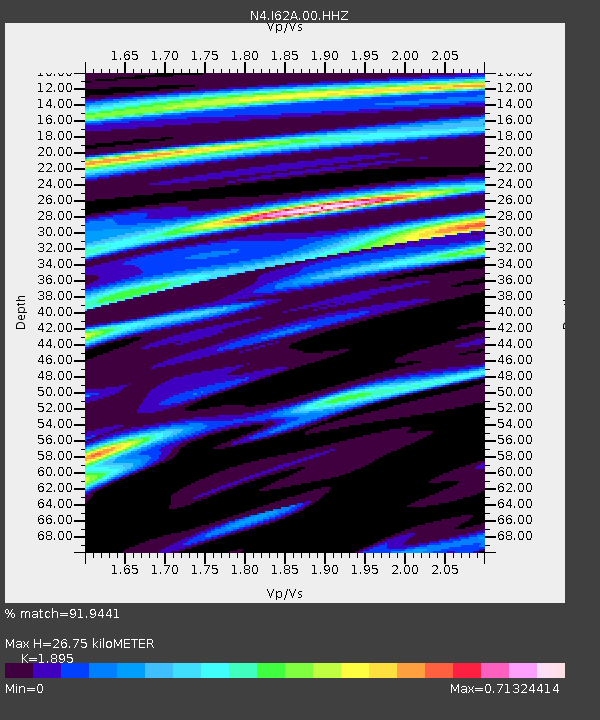
| Estimated Moho Depth: |
26.75 km |
| Estimated Crust Vp/Vs: |
1.89 |
| Assumed Crust Vp: |
6.419 km/s |
| Estimated Crust Vs: |
3.387 km/s |
| Estimated Crust Poisson's Ratio: |
0.31 |
|
| Radial Match: |
91.9441 % |
| Radial Bump: |
249 |
| Transverse Match: |
69.492065 % |
| Transverse Bump: |
400 |
| SOD ConfigId: |
25131211 |
| Insert Time: |
2021-10-06 10:18:31.559 +0000 |
| GWidth: |
2.5 |
| Max Bumps: |
400 |
| Tol: |
0.001 |
|

Signal To Noise
| Channel | StoN | STA | LTA |
| N4:I62A:00:HHZ:20210922T10:03:26.089996Z | 33.6124 | 4.867502E-6 | 1.4481269E-7 |
| N4:I62A:00:HH1:20210922T10:03:26.089996Z | 17.07132 | 2.6196499E-6 | 1.5345329E-7 |
| N4:I62A:00:HH2:20210922T10:03:26.089996Z | 17.81497 | 1.9635397E-6 | 1.1021853E-7 |
| Arrivals |
| Ps | 4.0 SECOND |
| PpPs | 11 SECOND |
| PsPs/PpSs | 15 SECOND |


