You are here: Home > Network List > US - United States National Seismic Network Stations List
> Station LONY Lake Ozonia, New York, USA > Earthquake Result Viewer
LONY Lake Ozonia, New York, USA - Earthquake Result Viewer
| Earthquake location: |
Near Coast Of Nicaragua |
| Earthquake latitude/longitude: |
12.1/-87.8 |
| Earthquake time(UTC): |
2021/09/22 (265) 09:57:07 GMT |
| Earthquake Depth: |
10 km |
| Earthquake Magnitude: |
6.7 Mi |
| Earthquake Catalog/Contributor: |
NEIC PDE/at |
|
| Network: |
US United States National Seismic Network |
| Station: |
LONY Lake Ozonia, New York, USA |
| Lat/Lon: |
44.62 N/74.58 W |
| Elevation: |
440 m |
|
| Distance: |
34.3 deg |
| Az: |
16.828 deg |
| Baz: |
203.359 deg |
| Ray Param: |
0.07779564 |
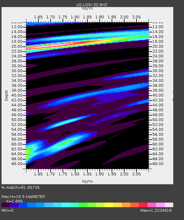
| Estimated Moho Depth: |
19.5 km |
| Estimated Crust Vp/Vs: |
1.70 |
| Assumed Crust Vp: |
6.419 km/s |
| Estimated Crust Vs: |
3.787 km/s |
| Estimated Crust Poisson's Ratio: |
0.23 |
|
| Radial Match: |
91.65735 % |
| Radial Bump: |
215 |
| Transverse Match: |
87.12809 % |
| Transverse Bump: |
298 |
| SOD ConfigId: |
25131211 |
| Insert Time: |
2021-10-06 10:24:18.068 +0000 |
| GWidth: |
2.5 |
| Max Bumps: |
400 |
| Tol: |
0.001 |
|
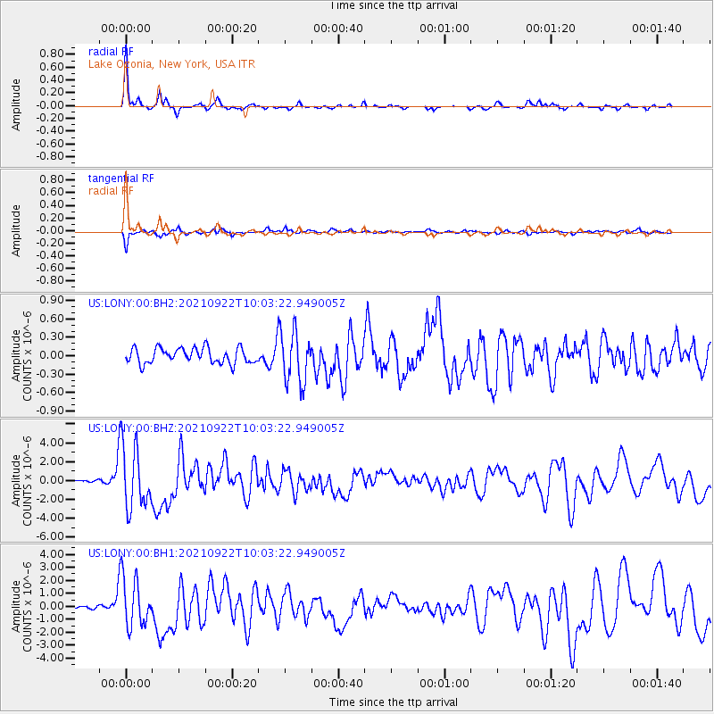
Signal To Noise
| Channel | StoN | STA | LTA |
| US:LONY:00:BHZ:20210922T10:03:22.949005Z | 22.392153 | 3.2954272E-6 | 1.4716883E-7 |
| US:LONY:00:BH1:20210922T10:03:22.949005Z | 18.074427 | 1.901243E-6 | 1.0518967E-7 |
| US:LONY:00:BH2:20210922T10:03:22.949005Z | 3.3576753 | 4.1952524E-7 | 1.2494515E-7 |
| Arrivals |
| Ps | 2.3 SECOND |
| PpPs | 7.6 SECOND |
| PsPs/PpSs | 9.8 SECOND |


