You are here: Home > Network List > UU - University of Utah Regional Network Stations List
> Station MOUT Mount Ogden, UT, USA > Earthquake Result Viewer
MOUT Mount Ogden, UT, USA - Earthquake Result Viewer
| Earthquake location: |
Near Coast Of Nicaragua |
| Earthquake latitude/longitude: |
12.1/-87.8 |
| Earthquake time(UTC): |
2021/09/22 (265) 09:57:07 GMT |
| Earthquake Depth: |
10 km |
| Earthquake Magnitude: |
6.7 Mi |
| Earthquake Catalog/Contributor: |
NEIC PDE/at |
|
| Network: |
UU University of Utah Regional Network |
| Station: |
MOUT Mount Ogden, UT, USA |
| Lat/Lon: |
41.20 N/111.88 W |
| Elevation: |
2748 m |
|
| Distance: |
35.9 deg |
| Az: |
328.289 deg |
| Baz: |
137.055 deg |
| Ray Param: |
0.07701097 |
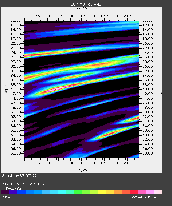
| Estimated Moho Depth: |
39.75 km |
| Estimated Crust Vp/Vs: |
1.74 |
| Assumed Crust Vp: |
6.155 km/s |
| Estimated Crust Vs: |
3.547 km/s |
| Estimated Crust Poisson's Ratio: |
0.25 |
|
| Radial Match: |
87.57172 % |
| Radial Bump: |
400 |
| Transverse Match: |
77.53467 % |
| Transverse Bump: |
400 |
| SOD ConfigId: |
25131211 |
| Insert Time: |
2021-10-06 10:25:28.469 +0000 |
| GWidth: |
2.5 |
| Max Bumps: |
400 |
| Tol: |
0.001 |
|

Signal To Noise
| Channel | StoN | STA | LTA |
| UU:MOUT:01:HHZ:20210922T10:03:36.029999Z | 39.077293 | 3.849788E-6 | 9.851727E-8 |
| UU:MOUT:01:HHN:20210922T10:03:36.029999Z | 24.903326 | 1.8862415E-6 | 7.5742555E-8 |
| UU:MOUT:01:HHE:20210922T10:03:36.029999Z | 8.658215 | 1.8093732E-6 | 2.0897762E-7 |
| Arrivals |
| Ps | 5.1 SECOND |
| PpPs | 16 SECOND |
| PsPs/PpSs | 22 SECOND |


